Weather
More Overnight Snow Possible For Philly Region After Blizzard: Forecasters
Winter will continue Tuesday night in the Philadelphia region, forecasters said.

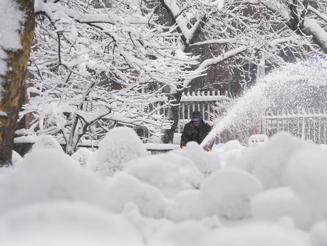
Another winter storm front is moving into eastern Pennsylvania just a day after a historic blizzard dropped anywhere from 10 to 20 inches of snow around the region, forecasters said.
This next front will be much lighter, with accumulations of around half an inch expected for much of the five-county southeastern Pennsylvania area, according to the National Weather Service. More significant impacts, from 1 to 3 inches of accumulation, are possible farther north and west.
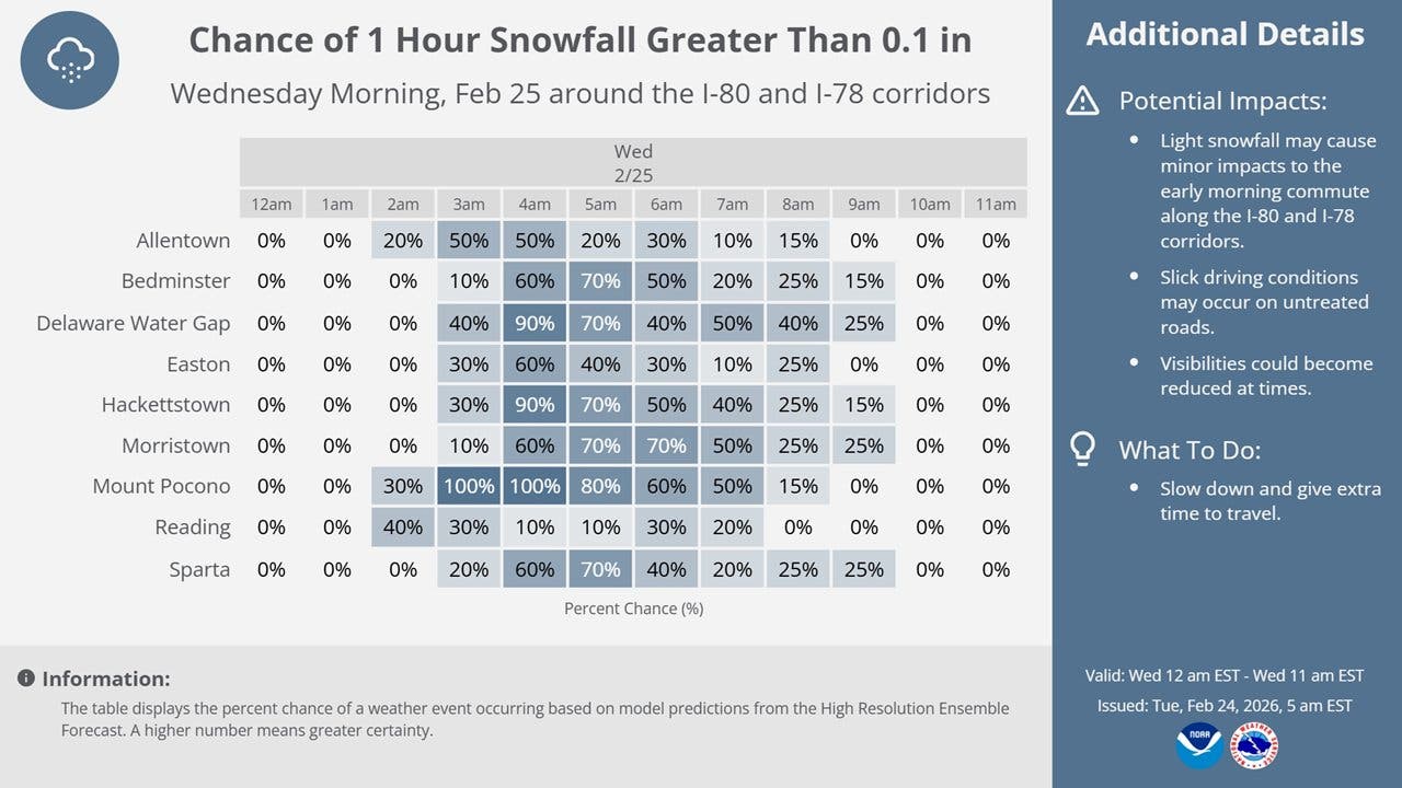
"Light snowfall may cause minor impacts to the early morning commute along the I-80 and I-78 corridors," the National Weather Service's Mt. Holly, New Jersey branch shared. "While accumulations will be on the lower side, the timing may lead to slick conditions during the morning commute."
Find out what's happening in Across Pennsylvaniafor free with the latest updates from Patch.
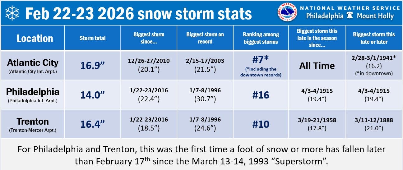
The additional precipitation comes on the heels of a blizzard that brought widespread power outages and shut down traffic for hours on Sunday into Monday. For Philadelphia, it was the biggest winter storm and the most snow accumulation since 2016.
The new storm is likely to arrive in the early morning hours of Wednesday, chiefly after 4 a.m., forecasters said.
Find out what's happening in Across Pennsylvaniafor free with the latest updates from Patch.
"While snow totals will not be as significant as the nor'easter, any streets and sidewalks that have already been cleared of any snow can become snow covered again," Accuweather added.
Another small winter storm could bring a third round of snow this week on Thursday, though it's expected to mix with rain and little to no accumulation is expected, according to forecasters.
Meanwhile, the strong sunshine on Tuesday could lead to some brief melting of the massive accumulations before the storm arrives.
Here's the full forecast for the coming week, according to the National Weather Service:
Tuesday
Mostly sunny, with a high near 33. Northwest wind 10 to 15 mph.
Tuesday Night
Snow likely, mainly after 4 a.m. Increasing clouds, with a low around 23. South wind 5 to 10 mph. Chance of precipitation is 60 percent. New snow accumulation of less than a half inch possible.
Wednesday
A chance of snow before 10 a.m., then a chance of rain between 10 a.m. and 1 p.m. Cloudy, then gradually becoming mostly sunny, with a high near 46. Southwest wind around 10 mph, with gusts as high as 20 mph. Chance of precipitation is 30 percent. New snow accumulation of less than a half inch possible.
Wednesday Night
Partly cloudy, with a low around 31. Southwest wind around 5 mph.
Thursday
Rain and snow likely, mainly after 1 p.m. Mostly cloudy, with a high near 41. Calm wind becoming northeast around 5 mph in the morning. Chance of precipitation is 60 percent. Little or no snow accumulation expected.
Thursday Night
A chance of rain and snow before 10 p.m., then a chance of rain between 10 p.m. and 4 a.m., then a chance of freezing rain after 4 a.m. Mostly cloudy, with a low around 28. Chance of precipitation is 50 percent. New precipitation amounts between a tenth and quarter of an inch possible.
Friday
A chance of freezing rain before 7am. Mostly sunny, with a high near 41. Chance of precipitation is 30 percent.
Friday Night
Mostly clear, with a low around 28.
Saturday
Mostly sunny, with a high near 48.
Saturday Night
Partly cloudy, with a low around 33.
Sunday
Mostly sunny, with a high near 42.
Sunday Night
Partly cloudy, with a low around 21.
Monday
A chance of rain and snow. Partly sunny, with a high near 33. Chance of precipitation is 40 percent.
Get more local news delivered straight to your inbox. Sign up for free Patch newsletters and alerts.


