Weather
Storms Target Philly Area: See Latest Forecast
The first significant precipitation in weeks could also bring unique hazards to the roads.


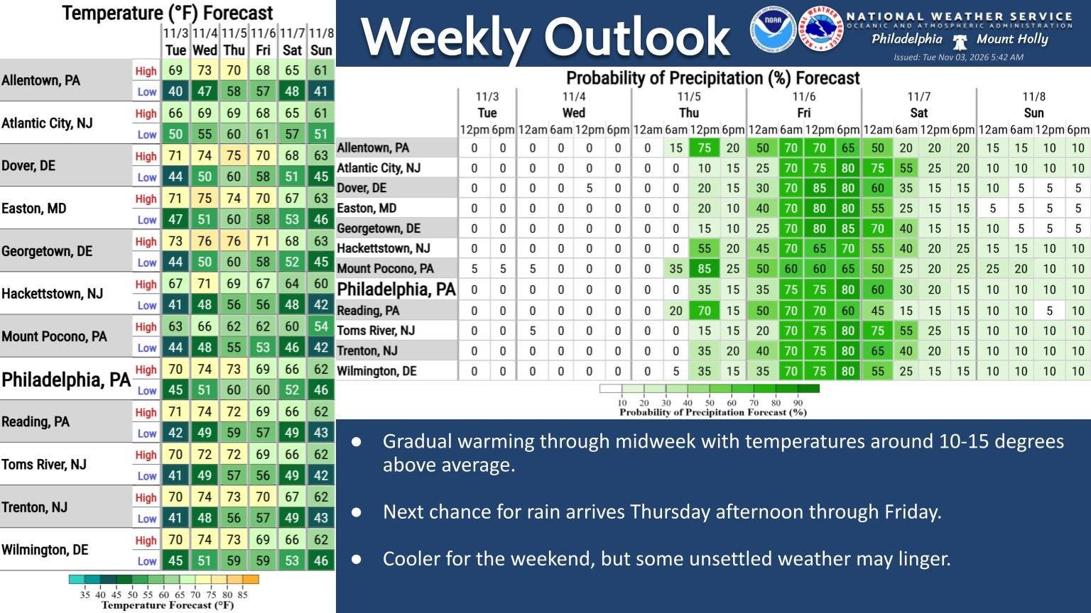
Multiple days of rainstorms are expected in the greater Philadelphia area this week, bringing the first significant precipitation in weeks to the region, according to forecasters.
Some showers could begin this afternoon as early as 3 p.m., with a higher chance after 5 p.m. More significant rain is expected later in the night and into the overnight hours.
Up to three quarters of an inch could fall tonight, with thunderstorms also possible between 11 p.m. and 4 a.m.
Find out what's happening in Across Pennsylvaniafor free with the latest updates from Patch.
Rain will return on Friday and continue into the early evening, with another three quarters of an inch of precipitation possible throughout the day. The National Weather Service calls for 1 to 1.5 inches in total.
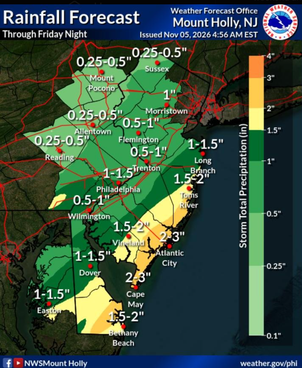
Rain is likely to be abate by later Friday. Friday morning and afternoon are the periods where precipitation is most likely, forecasters said.
Find out what's happening in Across Pennsylvaniafor free with the latest updates from Patch.
This precipitation will bring unique hazards to the roads, analysts said, in part due to wet leaves and other underlying conditions.
"As the first drops fall and wet the pavement, the buildup of oil, dust and other residues on the roads will form a slippery mixture," Accuweather said. "Tires may not grip as well as they typically do in routine wet conditions, so extra stopping distance will be needed at intersections and ramps. Some motorists may need to drive at lower-than-usual speeds to navigate winding roads."
Things look to dry out in time for the weekend and into next week.
Here's the full forecast for the coming week:
Thursday
A chance of rain before 3 p.m., then a slight chance of rain after 5 p.m. Partly sunny, with a high near 74. South wind around 10 mph, with gusts as high as 20 mph. Chance of precipitation is 40 percent. New precipitation amounts of less than a tenth of an inch possible.
Thursday Night
A chance of rain and thunderstorms before 11 p.m., then rain likely and possibly a thunderstorm between 11 p.m. and 4 a.m., then rain after 4 a.m. Patchy fog after 1 a.m. Low around 63. South wind around 5 mph becoming west after midnight. Chance of precipitation is 80 percent. New rainfall amounts between a half and three quarters of an inch possible.
Friday
Rain, mainly before 3 p.m. Patchy fog between 9 a.m. and 10 a.m. High near 70. Calm wind becoming northwest around 5 mph. Chance of precipitation is 90 percent. New precipitation amounts between a quarter and half of an inch possible.
Friday Night
Partly cloudy, with a low around 52. Calm wind becoming northwest around 5 mph.
Saturday
Mostly sunny, with a high near 63. West wind 5 to 10 mph.
Saturday Night
Mostly clear, with a low around 45.
Sunday
Sunny, with a high near 61.
Sunday Night
Mostly clear, with a low around 43.
Monday
Sunny, with a high near 61.
Monday Night
Mostly clear, with a low around 42.
Tuesday
Sunny, with a high near 65.
Tuesday Night
Mostly clear, with a low around 43.
Veterans Day
Sunny, with a high near 62.
Get more local news delivered straight to your inbox. Sign up for free Patch newsletters and alerts.