Weather
New Map Reveals Possible PA Impacts From Weekend Storm
A developing storm along the coast is expected to turn into a "bomb cyclone," with a potential for more snow, forecasters said.

A developing winter storm front along the east coast could turn into a "bomb cyclone," with the potential for a few more inches of snow falling this weekend in eastern Pennsylvania, forecasters said.
It's not yet clear exactly how much, if any, snow will accumulate, as there is still some variability to forecasts. The most likely track of the storm seems to have it brushing the area.
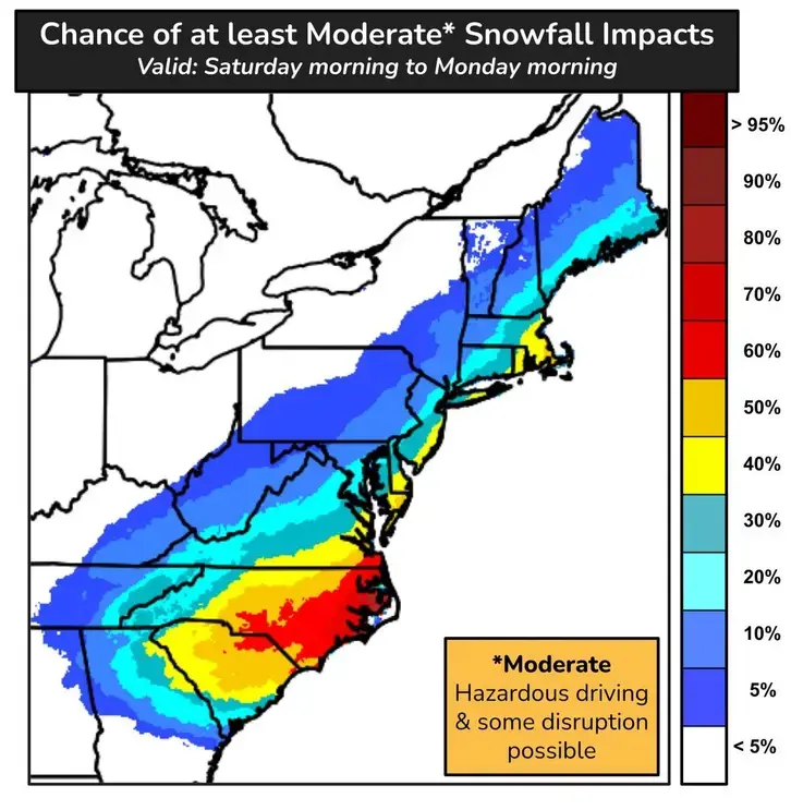
"While strong winds and coastal flooding are becoming bigger risks, snowfall remains highly uncertain," the National Weather Service's Mt. Holly, New Jersey branch shared.
Find out what's happening in Across Pennsylvaniafor free with the latest updates from Patch.
However, forecasters added that the greater Philadelphia area currently has between a 10 and 20 percent chance of "moderate" snowfall of around 5 inches.
Bomb cyclones develop when atmospheric pressure suddenly drops, causing the storm to rapidly intensity. Forecasters don't seem to doubt that the bomb cyclone will develop, but they are just uncertain how far into the coast it will penetrate.
Find out what's happening in Across Pennsylvaniafor free with the latest updates from Patch.
"The track of the storm relative to the coast will not only determine how much snow falls in the Southeast from Friday to Saturday, but also how far inland heavy snow can penetrate in the mid-Atlantic and New England from Saturday to Sunday as the storm spins over the Atlantic," Accuweather said.
Because of the nature of the storm, there could be a very sharp line between significant accumulations and very minor accumulations, with the I-95 line potentially serving as the "boundary between accumulating snow and practically no snow at all," Accuweather added. Less than a dozen miles could separate several inches of snow to a dusting of snow.
The storm is expected to arrive at some point Saturday morning, and impacts could continue to Monday morning.
Frigid temperatures will also continue over the next few days, with wind chills dropping to negative eight Thursday. Cold weather will stick around into next week, priming air and the ground for another potential storm. Any precipitation that does fall will certainly be snow.
Warmer temperatures are expected to arrive later next week.
Here's the full forecast for the coming week, according to the National Weather Service:
Wednesday
Increasing clouds, with a high near 20. West wind around 5 mph.
Wednesday Night
Partly cloudy, with a low around 5. Wind chill values as low as -2. West wind around 5 mph becoming calm after midnight.
Thursday
Mostly sunny, with a high near 19. Wind chill values as low as -8. West wind around 10 mph.
Thursday Night
Mostly clear, with a low around 2. Wind chill values as low as -8. West wind around 5 mph.
Friday
Mostly sunny, with a high near 18. West wind 5 to 10 mph, with gusts as high as 20 mph.
Friday Night
Mostly cloudy, with a low around 2.
Saturday
Mostly cloudy, with a high near 19.
Saturday Night
A chance of snow after 1 a.m. Cloudy, with a low around 13. Chance of precipitation is 30 percent.
Sunday
A chance of snow. Cloudy, with a high near 24. Blustery. Chance of precipitation is 40 percent.
Sunday Night
Mostly cloudy, with a low around 16.
Monday
Partly sunny, with a high near 31.
Monday Night
Mostly cloudy, with a low around 16.
Tuesday
Partly sunny, with a high near 30
Get more local news delivered straight to your inbox. Sign up for free Patch newsletters and alerts.