Weather
Record Heat Looms In Philly Region Forecast: Timing, Details
Forecasters touted "high confidence" in records being set in the coming days.

A significant shift in the weather pattern in the coming days will bring a heat wave through the greater Philadelphia area, potentially breaking long-standing records, forecasters said.
Temperatures will hit the low to mid 80s throughout much of the region Monday, and will rise by several degrees into the upper 80s Tuesday.
The upwards trend will continue on Wednesday and Thursday, with highs of 90 or more forecasted in the city and many outlying suburbs.
Find out what's happening in Across Pennsylvaniafor free with the latest updates from Patch.
"(There is) high confidence in records potentially being set, mainly on Wednesday and Thursday, where the I-95 corridor and Delmarva could see their first 90 degree days of the year," the National Weather Service's Mt. Holly, New Jersey branch shared.
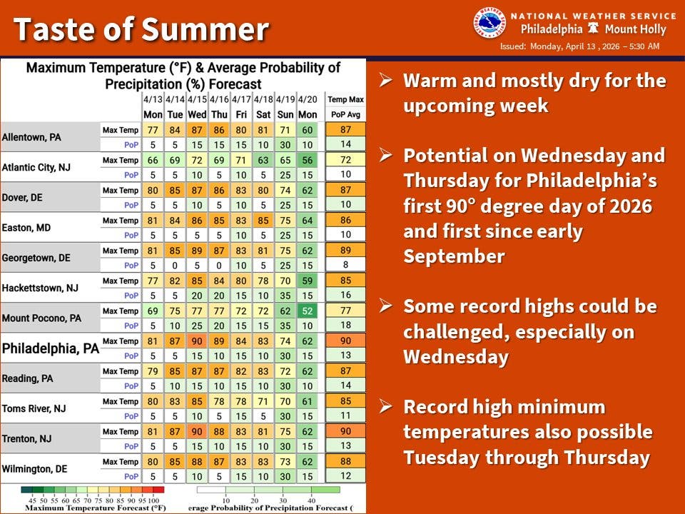
The all time record high for April 15, 88 degrees, was set in 1941, according to National Weather Service records.
Find out what's happening in Across Pennsylvaniafor free with the latest updates from Patch.
The region has not seen a 90-degree day since last September.
There remains a small chance of a front of thunderstorms coming across the midwest and northern Pennsylvania hitting the area on Wednesday, but the likelihood has continue to go down, forecasters said. Showers could hit Wednesday night.
Hot and sunny conditions are likely to continue, with highs in the mid to upper 80s, into the weekend. Another chance of showers is in the forecast for Saturday night into Sunday.
Cooling centers across the region will likely open as the heat index rises.
Here's the full forecast for the Philadelphia region, according to the National Weather Service:
Monday
Partly sunny, with a high near 82. West wind around 15 mph, with gusts as high as 30 mph.
Monday Night
Mostly clear, with a low around 61. West wind 5 to 10 mph.
Tuesday
Mostly sunny, with a high near 87. Light southwest wind increasing to 5 to 10 mph in the morning. Winds could gust as high as 20 mph.
Tuesday Night
Partly cloudy, with a low around 66. Southwest wind around 5 mph.
Wednesday
A slight chance of showers after 2 p.m. Mostly sunny, with a high near 90. Southwest wind 5 to 10 mph. Chance of precipitation is 20 percent.
Wednesday Night
A chance of showers, mainly between 8 p.m. and 2 a.m. Mostly cloudy, with a low around 67. Chance of precipitation is 30 percent.
Thursday
Partly sunny, with a high near 90.
Thursday Night
Mostly cloudy, with a low around 67.
Friday
Mostly sunny, with a high near 85.
Friday Night
Partly cloudy, with a low around 61.
Saturday
Mostly sunny, with a high near 84.
Saturday Night
A chance of showers. Mostly cloudy, with a low around 59. Chance of precipitation is 40 percent.
Sunday
A chance of showers. Partly sunny, with a high near 77. Chance of precipitation is 40 percent.
To stay cool, local health officials offer the following tips:
- Use air conditioners. If necessary, go to an air-conditioned location for several hours during the hottest parts of the day.
- If using a fan, be sure to open windows to release trapped hot air.
- Drink plenty of liquids, especially water, to prevent dehydration. Avoid caffeine and alcohol.
- Never leave older people, children, or pets alone in cars.
- Those taking regular medication should consult with their physician. Some medications cause an adverse reaction in hot weather.
- Wear lightweight, light-colored clothing.
- Avoid, as much as possible, working or playing in the hot sun or other hot areas, especially during the sun’s peak hours of 11 a.m. through 4 p.m.
- Maintain a normal diet.
- Cover all exposed skin with an SPF sunscreen (15 or above). Wear a wide-brimmed hat to protect your face and head. Apply sunscreen under your mask to protect your face.
Get more local news delivered straight to your inbox. Sign up for free Patch newsletters and alerts.