Weather
Severe Heat To Hit Philly Area, Thunderstorms Loom: Forecast
The heat index will soar to 105 as the most brutal heat in weeks hits the region. Storms may loom for days. Details:

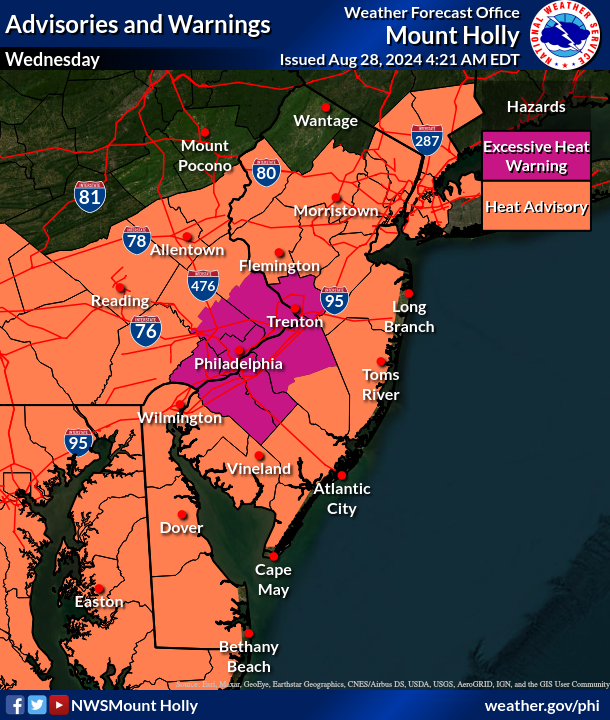
EASTERN PA — Dangerous heat will return to the greater Philadelphia area Wednesday, and could be followed up by a severe storm later in the afternoon, according to forecasters.
Temperatures will reach 97 degrees and the heat index will soar to around 105 in the city and around the five county area, marking the most brutal weather in weeks and spurring an excessive heat warning from the National Weather Service.
"If you are outside, make sure to drink plenty of water and take frequent breaks," the National Weather Service's Mt. Holly, New Jersey station said in a statement.
Find out what's happening in Across Pennsylvaniafor free with the latest updates from Patch.
The storms won't roll through until around 7 p.m., if they do come at all, as forecasters warn there is still a lot of variability in the forecast.
There's a 40 percent chance of showers and thunderstorms in the evening, and up to a tenth of an inch of rain could fall, though that amount will be significantly higher in the heart of the thunderstorms.
Find out what's happening in Across Pennsylvaniafor free with the latest updates from Patch.
A chance for storms will continue overnight into Thursday, and will not fully abate until later Sunday evening, with rain and thunder looming over the region for the next several days.
Here's the full forecast:
Wednesday
Mostly sunny and hot, with a high near 97. Heat index values as high as 105. West wind 5 to 10 mph.
Wednesday Night
A chance of showers and thunderstorms, mainly after 7 p.m. Mostly cloudy, with a low around 70. Northwest wind 5 to 10 mph becoming northeast after midnight. Chance of precipitation is 40 percent. New rainfall amounts between a tenth and quarter of an inch, except higher amounts possible in thunderstorms.
Thursday
A slight chance of showers before 7 a.m., then a slight chance of showers after 2 p.m. Mostly cloudy, with a high near 79. East wind around 10 mph. Chance of precipitation is 20 percent.
Thursday Night
A chance of showers and thunderstorms before 11 p.m., then a chance of showers between 11 p.m. and 5 a.m., then a chance of showers and thunderstorms after 5 a.m. Mostly cloudy, with a low around 66. East wind 5 to 10 mph. Chance of precipitation is 30 percent. New rainfall amounts between a quarter and half of an inch possible.
Friday
A slight chance of showers and thunderstorms. Partly sunny, with a high near 77. East wind around 5 mph. Chance of precipitation is 20 percent.
Friday Night
A slight chance of showers after 2 a.m. Mostly cloudy, with a low around 68. Chance of precipitation is 20 percent.
Saturday
A chance of showers and thunderstorms after 2 p.m. Mostly cloudy, with a high near 85. Chance of precipitation is 50 percent.
Saturday Night
A chance of showers and thunderstorms before 8 p.m., then showers likely and possibly a thunderstorm between 8 p.m. and 2 a.m., then a chance of showers and thunderstorms after 2 a.m. Mostly cloudy, with a low around 71. Chance of precipitation is 70 percent.
Sunday
A chance of showers before 8 a.m., then a chance of showers after 2 p.m. Partly sunny, with a high near 86. Chance of precipitation is 30 percent.
Sunday Night
A chance of showers before 2 a.m. Partly cloudy, with a low around 68. Chance of precipitation is 30 percent.
Get more local news delivered straight to your inbox. Sign up for free Patch newsletters and alerts.


