Weather
Damaging Winds, Flooding Possible During Severe Storms In Eastern PA Monday: See Timing
An isolated tornado could also form during the severe thunderstorms, which are forecast to arrive Monday evening and linger into Tuesday.

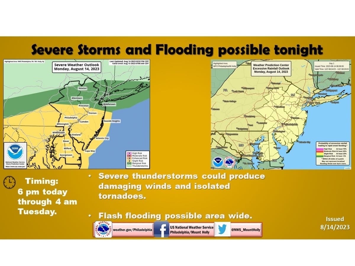
PENNSYLVANIA — Severe weather looms again Monday in southeastern Pennsylvania, with damaging winds and flooding as the main threats when storms arrive in the evening, said weather experts.
AccuWeather said a number of cities from the Ohio River Valley to the Mid-Atlantic coast are at risk of heavy rain, lightning, and damaging wind gusts between 60 and 70 miles per hour, beginning Monday evening. An isolated tornado could also form during severe thunderstorms, according to AccuWeather and the National Weather Service.
Forecasters predict that thunderstorms will move into the region at about 6 p.m. Monday, and last until around 4 a.m. Tuesday.Widespread rainfall may bring more than 2 inches of rain to some areas of the Keystone State, the National Weather Service said in an updated forecast.
Find out what's happening in Across Pennsylvaniafor free with the latest updates from Patch.
Weather in Pennsylvania on Monday will be “very warm but mostly dry” until storms arrive, forecasters added. Humidity could ramp up into the afternoon, as well.
“Much more active weather arrives tonight into Tuesday, with the risk of flooding and damaging winds being paramount,” said the NWS office in Mount Holly.
Find out what's happening in Across Pennsylvaniafor free with the latest updates from Patch.
Along with possible wind damage, forecasters said the slow-moving frontal boundary of the storm could dump excessive amounts of rain on some communities.
"The very tricky part is there is quite a bit of uncertainty of exactly how quickly this front will move and how far north it will end up and, therefore, who will see the heaviest amount of rain and greatest risk for both flash flooding and severe thunderstorms," NWS forecasters said in a Monday afternoon update.
Almost all Pennsylvania counties are under a hazardous weather outlook Monday afternoon; including Allegheny, Beaver, Bucks, Butler, Chester, Delaware, Lehigh, Montgomery, Philadelphia, and Washington counties, per the NWS.
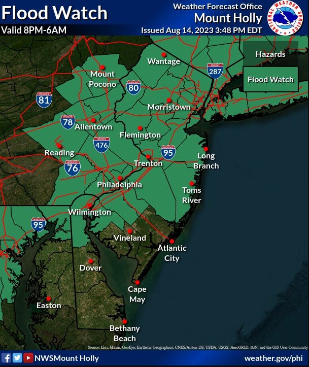
And, all counties in eastern Pennsylvania are under a flood watch from 8 p.m. Monday until 6 a.m. Tuesday, the NWS said. There is an elevated risk for excessive rainfall in the Philadelphia region, per the NWS.
The Philadelphia region is in a “slight” chance of severe weather for Monday evening, meaning that scattered severe thunderstorms are possible in isolated areas, according to the National Weather Service.
This stormy pattern could continue Tuesday in parts of southeastern Pennsylvania, though the risk of tornadoes should be higher Monday, according to AccuWeather meteorologist La Troy Thornton.
"Monday should present a higher tornado threat as opposed to Tuesday because of stronger turning of the winds with height or shear," explained Thornton. “This phenomenon allows for the columns of rising air that build thunderstorms, called updrafts, to rotate, and this rotation can lead to tornadoes if it can be maximized and sustained.”
Last week, the National Weather Service confirmed that a tornado caused "extensive damage" in an Allentown neighborhood. Pennsylvania averages about 16 tornadoes per year, and has already reached a tally of 20 this year according to the National Oceanic and Atmospheric Administration.
Here is a look at Monday’s forecast in southeastern Pennsylvania, according to the National Weather Service:
Monday: Partly sunny, with a high near 90. Calm wind becoming southwest around 5 mph in the afternoon.
Monday night: Showers and thunderstorms before 2 a.m., then showers likely and possibly a thunderstorm between 2 a.m. and 5 a.m., then a chance of showers and thunderstorms after 5 a.m. Some of the storms could produce gusty winds and heavy rain. Low around 74. Southeast wind around 5 mph. Chance of precipitation is 90 percent. New rainfall amounts between 1 and 2 inches possible.
Get more local news delivered straight to your inbox. Sign up for free Patch newsletters and alerts.