Weather
Severe Thunderstorms Possible In Philly Area As Massive Temperature Shift Expected
Near record heat will give way to a cold front that could plummet temperatures by 40 degrees.

Severe thunderstorms are possible this week in the Philadelphia area as the region looks to experience a drastic temperature swing, forecasters said.
Potential record high temperatures are possible Tuesday, with a high of 78 expected in the city. However, the storm will bring a cold front that will drop temperatures roughly 40 degrees in just two days, with lows in the upper 30s expected Thursday.
The storm front will arrive in the early afternoon hours of Wednesday, with some rain possible throughout the day.
Find out what's happening in Across Pennsylvaniafor free with the latest updates from Patch.
Precipitation will grow more likely into the night, with thunderstorms, possibly turning severe, hitting overnight. The National Weather Service's Mt. Holly, New Jersey branch says the severity and range of storms will "depend on the timing" but advises residents to "keep in mind the potential."
Still, forecasters are warning residents to be prepared. The same storm front is expected to have serious impacts in parts of the midwest as it approaches the east.
Find out what's happening in Across Pennsylvaniafor free with the latest updates from Patch.
"Hail, damaging wind gusts of 60-70 mph and isolated tornadoes could accompany any severe thunderstorm," Accuweather says. "Those traveling to and from any airports in the region, as well as on roadways...should prepare for potential delays."
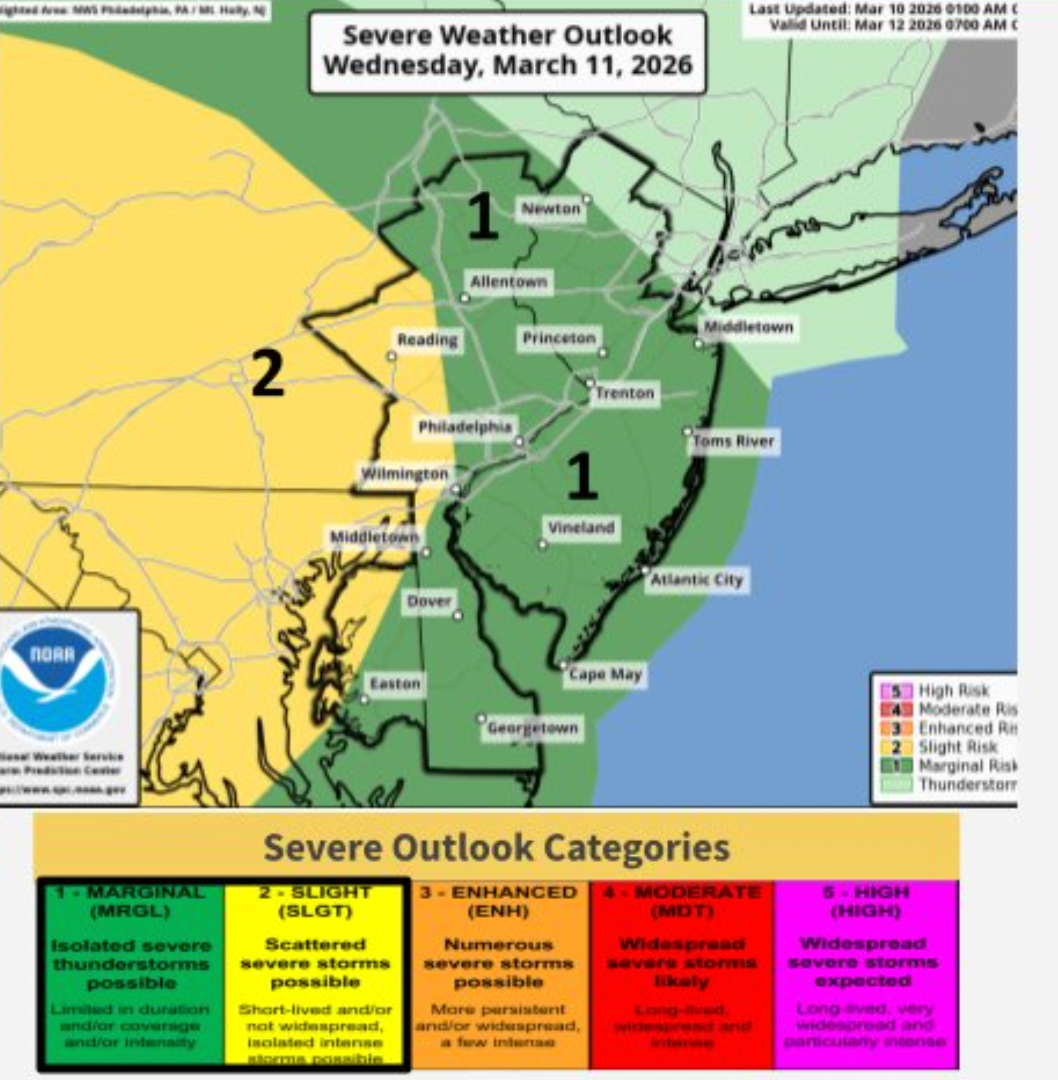
Most of the five county area is in the NWS's "slight" category of expected impacts, which is the second most severe.
The storm will continue into the day Thursday, with an elevated chance of rain and thunderstorms, the National Weather Service said. Rain could continue into the evening hours Thursday.
"A large swath of drenching showers and heavy, gusty thunderstorms will extend from the Gulf to much of the Atlantic seaboard Thursday," Accuweather adds.
Here's the full forecast for Philly region for the coming week, according to the National Weather Service:
Tuesday
Sunny, with a high near 78. Southwest wind 5 to 10 mph.
Tuesday Night
Mostly clear, with a low around 52. South wind around 5 mph.
Wednesday
A chance of showers after 2 p.m. Increasing clouds, with a high near 76. South wind 5 to 10 mph, with gusts as high as 20 mph. Chance of precipitation is 30 percent. New precipitation amounts of less than a tenth of an inch possible.
Wednesday Night
A chance of showers, then showers likely and possibly a thunderstorm after 2 a.m. Mostly cloudy, with a low around 56. South wind 10 to 15 mph. Chance of precipitation is 60 percent. New rainfall amounts of less than a tenth of an inch, except higher amounts possible in thunderstorms.
Thursday
Showers likely and possibly a thunderstorm. Mostly cloudy, with a high near 59. Breezy, with a northwest wind 15 to 20 mph, with gusts as high as 30 mph. Chance of precipitation is 60 percent. New precipitation amounts between a tenth and quarter of an inch, except higher amounts possible in thunderstorms.
Thursday Night
A chance of showers before 8 p.m. Partly cloudy, with a low around 33. Chance of precipitation is 30 percent. New precipitation amounts of less than a tenth of an inch possible.
Friday
Partly sunny, with a high near 50.
Friday Night
Mostly cloudy, with a low around 40.
Saturday
Partly sunny, with a high near 53.
Saturday Night
Mostly cloudy, with a low around 39.
Sunday
Mostly cloudy, with a high near 61.
Sunday Night
Rain. Low around 47. Chance of precipitation is 90 percent.
Monday
Rain. High near 58. Chance of precipitation is 80 percent.
Get more local news delivered straight to your inbox. Sign up for free Patch newsletters and alerts.