Weather
Snow Chances, Wind Gusts, Subzero Temperatures: Latest PA Forecast
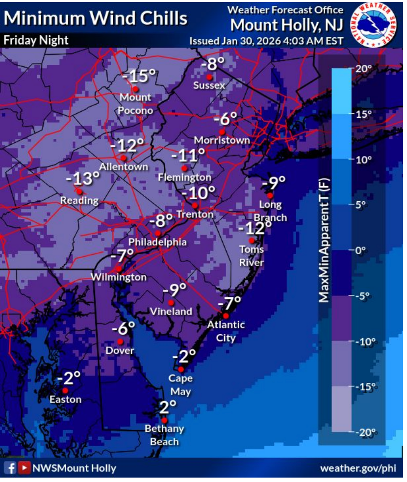
The storm this weekend may not accumulate snow in the Philly area, but wind chills dropping to negative 15 will pose plenty danger.

The chances of significant snow in the Philadelphia area from the coming storm have largely fizzled out, forecasters said in their latest update Friday morning, reversing loose estimates from Thursday that showed up to a 40 percent chance of several inches of accumulation.
The National Weather Service now believes most of the Philly area and surrounding suburbs will receive a dusting of snow or nothing at all. The more significant snow will fall along the coastal areas and in southern New Jersey, where anywhere from 1 to 3 inches is expected.
Forecasters did warn that the storm remains highly variable as it heads up the coastline and is subject to change.
Find out what's happening in Across Pennsylvaniafor free with the latest updates from Patch.
"These (snowfall estimates) could change in either direction depending on the exact track of the storm," the National Weather Service's Mt. Holly, New Jersey branch shared.
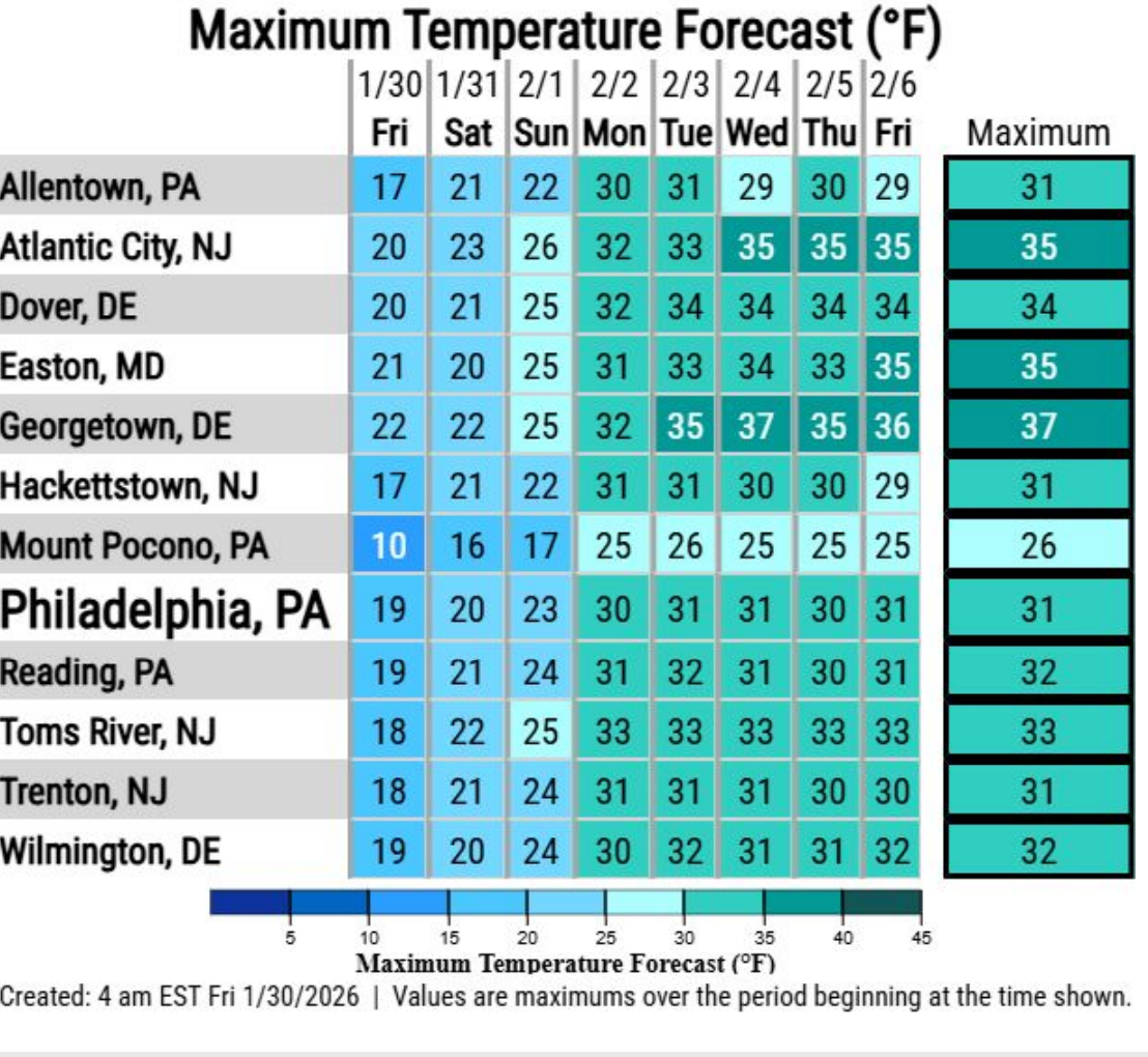
However, even without snow, the temperatures will get dangerously cold over the coming days, as a cold weather advisory remains in effect for the entire region. Wind chills between 0 and negative 15 degrees are expected from Friday night through Sunday, with temperatures dropping to 3 on Friday night and 9 on Saturday night.
Find out what's happening in Across Pennsylvaniafor free with the latest updates from Patch.
That will lead to an "increased risk of hypothermia and frostbite," forecasters said.
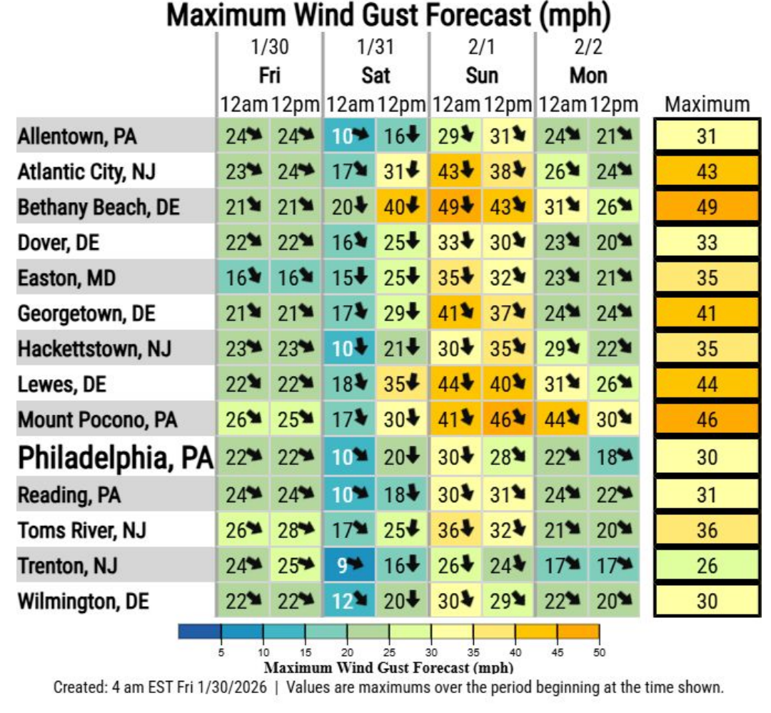
There will also be wind gusts up to 50 miles per hour in parts of the region, potentially knocking down trees and power lines.
This is particularly a risk where snow and ice has already accumulated on branches of trees and wires, weighing them down, officials said.
The severe cold is expected to continue well into next week. The longer the period of sub-freezing temperatures, "the higher the risk of impacts including topeople and infrastructure," the National Weather Service said.
Preliminary long range forecasts have another chance of snow next Wednesday in the Philadelphia area, though estimates on snow accumulations have not yet been released.
Here's the full forecast for the coming week, according to the National Weather Service:
Friday
Mostly sunny, with a high near 19. Wind chill values as low as -2. West wind 10 to 15 mph.
Friday Night
Partly cloudy, with a low around 3. Wind chill values as low as -7. Northwest wind around 5 mph.
Saturday
Partly sunny, with a high near 20. Wind chill values as low as -8. North wind around 5 mph.
Saturday Night
A slight chance of snow after 1 a.m. Mostly cloudy, with a low around 9. Wind chill values as low as -6. North wind 5 to 15 mph, with gusts as high as 30 mph. Chance of precipitation is 20 percent.
Sunday
Partly sunny, with a high near 23. Northwest wind around 15 mph, with gusts as high as 30 mph.
Sunday Night
Partly cloudy, with a low around 13.
Monday
Sunny, with a high near 30.
Monday Night
Mostly clear, with a low around 15.
Tuesday
Mostly sunny, with a high near 31.
Tuesday Night
Partly cloudy, with a low around 17.
Wednesday
A chance of snow. Partly sunny, with a high near 31. Chance of precipitation is 30 percent.
Wednesday Night
A chance of snow. Mostly cloudy, with a low around 18. Chance of precipitation is 40 percent.
Thursday
Mostly sunny, with a high near 30.
Get more local news delivered straight to your inbox. Sign up for free Patch newsletters and alerts.