Weather
Snow Chances Increase In Eastern PA: Latest Details, Timing
The coming storm could bring the first snow of the season to many parts of suburban Philadelphia. Details, timing:


EASTERN PENNSYLVANIA — The first snow of the year could be on the way to much of the greater Philadelphia area, forecasters said, as the region sees its first prolonged period of precipitation in more than a month.
The rain and snow, should they arrive and linger, could help to minimize the recent extreme heightened risk of wildfires around the region.
Some rain showers are possible throughout the morning Thursday, with rain possibly turning to snow overnight Thursday.
Find out what's happening in Across Pennsylvaniafor free with the latest updates from Patch.
The most significant precipitation will likely be Friday morning, with up to half an inch of snow accumulation possible, forecasters said. However, any snow in suburban Philadelphia will almost certainly turn to rain by noon.
Another dusting is possible late Friday before the system departs. The weekend forecast is clear and cool.
Find out what's happening in Across Pennsylvaniafor free with the latest updates from Patch.
Here is a map of the latest accumulation predictions:
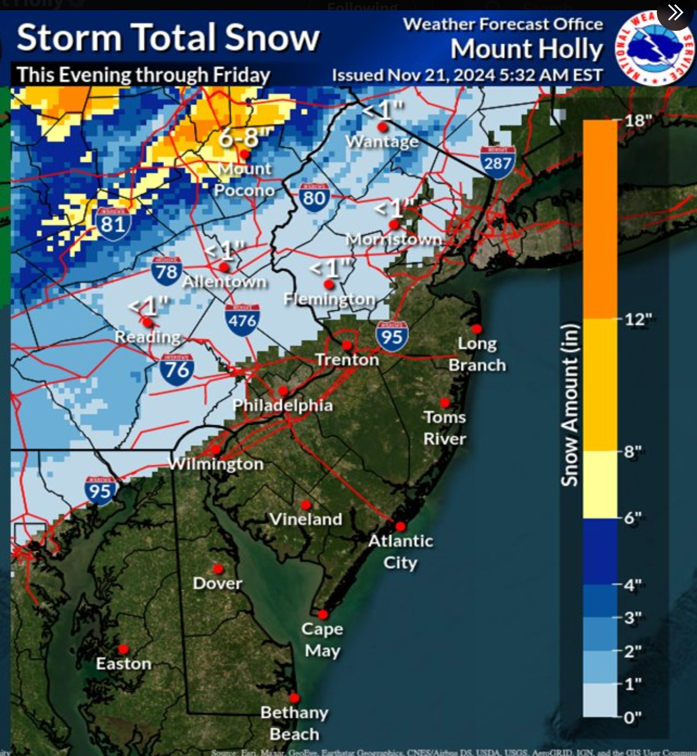
The bulk of the snow chances are in the Poconos, the higher elevations, and the farther outlying suburbs, forecasters said. But there's a chance that cold air lingers enough to drag snow showers down to the Philly area.
"Accumulations will be tough as temps likely stay a couple degrees above freezing, but we are forecasting light accumulations, especially on the higher hills, reaching to just northwest of the city [Philadelphia] and I-95," the National Weather Service said. "So, certainly the potential first appearance of snow across a significant portion of the area."
In northeastern Pennsylvania, up to two inches could fall.
Here's the full forecast for suburban Philadelphia, according to the National Weather Service:
Thursday
Showers likely, mainly before 1 p.m. Cloudy, with a high near 45. Northwest wind around 15 mph. Chance of precipitation is 60 percent. New precipitation amounts between a tenth and quarter of an inch possible.
Thursday Night
A chance of rain showers before 4 a.m., then a chance of snow showers. Mostly cloudy, with a low around 33. West wind 10 to 15 mph. Chance of precipitation is 30 percent. New snow accumulation of less than a half inch possible.
Friday
Rain and snow showers likely, becoming all rain after 11 a.m. Cloudy, with a high near 40. South wind 10 to 15 mph. Chance of precipitation is 60 percent. New snow accumulation of less than a half inch possible.
Friday Night
A chance of showers before 1 a.m. Cloudy, then gradually becoming partly cloudy, with a low around 32. West wind around 10 mph. Chance of precipitation is 30 percent. New precipitation amounts of less than a tenth of an inch possible.
Saturday
Mostly sunny, with a high near 49. West wind 10 to 15 mph, with gusts as high as 30 mph.
Saturday Night
Partly cloudy, with a low around 37.
Sunday
Mostly sunny, with a high near 50.
Get more local news delivered straight to your inbox. Sign up for free Patch newsletters and alerts.