Weather
Snowfall Estimates Increase As Pair Of Winter Storms Target PA
The first round of snow was expected to move through the state on Saturday, followed by a second round on Sunday. See the latest timing.

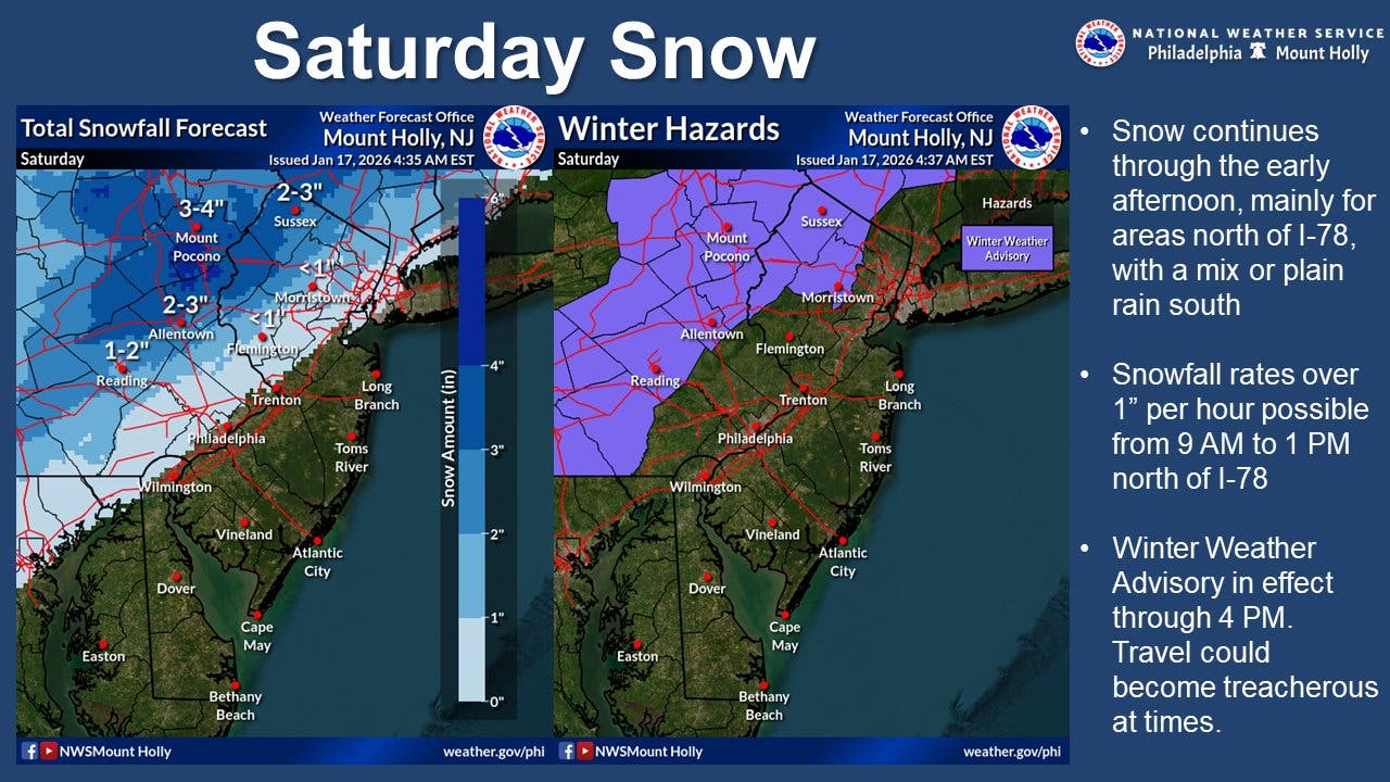
Portions of the greater Philadelphia region could now see up to two inches of snow on Saturday as the first of two winter storms moves through the state this weekend, according to the latest forecasts.
In its latest forecast, the National Weather Service said the first round of snow would move into the region on Saturday morning, with snowfall continuing into the afternoon hours, particularly in the Lehigh Valley, Poconos, and northern New Jersey.
A winter weather advisory is in effect until 4 p.m. Saturday for parts of Bucks, Montgomery and Chester counties, where up to two inches of snow could fall, the National Weather Service said.
Find out what's happening in Across Pennsylvaniafor free with the latest updates from Patch.
According to forecasters, areas north of Interstate 78 could see snowfall rates of more than 1 inch per hour.
The storm will continue into the afternoon, possibly mixing with rain or turning into rain after 1 p.m., forecasters said.
Find out what's happening in Across Pennsylvaniafor free with the latest updates from Patch.
A second front will arrive from the coast on early Sunday morning, with a slight chance of rain or snow overnight and then a slightly higher chance between 7 a.m. and 1 p.m., forecasters said.
Areas south and east of Interstate 95 are likely to see the most accumulation.
Philadelphia and immediate suburbs have about a 24 percent chance of another inch of accumulation, while the likelihood drops to around 16 percent for suburbs west and north.
Regardless of the final accumulation, the conditions will be significant enough to cause issues on the roads, even if it's mostly freezing rain that falls. Temperatures will plummet to 21 overnight Sunday and then down to 15 on Monday, meaning that remaining moisture on roads could quickly freeze over.
"The conditions may be wintry enough to prompt aircraft deicing operations, which can delay flights," Accuweather added.
Here's a look at the detailed National Weather Service forecast for the Philadelphia area:
Saturday: Snow likely, mixing with rain after 1pm, then gradually ending. Mostly cloudy, with a high near 39. Southwest wind 5 to 10 mph, with gusts as high as 20 mph. Chance of precipitation is 70%. Little or no snow accumulation expected.
Saturday Night: A slight chance of snow after 4am. Increasing clouds, with a low around 30. Southwest wind around 5 mph becoming calm in the evening. Chance of precipitation is 20%.
Sunday: A chance of snow. Cloudy, with a high near 35. Calm wind becoming northwest around 5 mph in the afternoon. Chance of precipitation is 50%. New snow accumulation of around an inch possible.
Sunday Night: Mostly cloudy, then gradually becoming mostly clear, with a low around 21. West wind around 5 mph.
Monday: Sunny, with a high near 35. Southwest wind 5 to 15 mph.
Monday Night: Partly cloudy, with a low around 15.
Tuesday: Sunny, with a high near 23.
Get more local news delivered straight to your inbox. Sign up for free Patch newsletters and alerts.