Weather
Timeline For Shift To Snow In PA: What To Expect
Near-record heat this week may have had you thinking otherwise, but winter isn't over yet.

After a week that's seen a severe thunderstorms, heavy winds, near-record high temperatures, and a 43-degree temperature swing in a swingle day, the chaotic weather pattern will continue in eastern Pennsylvania.
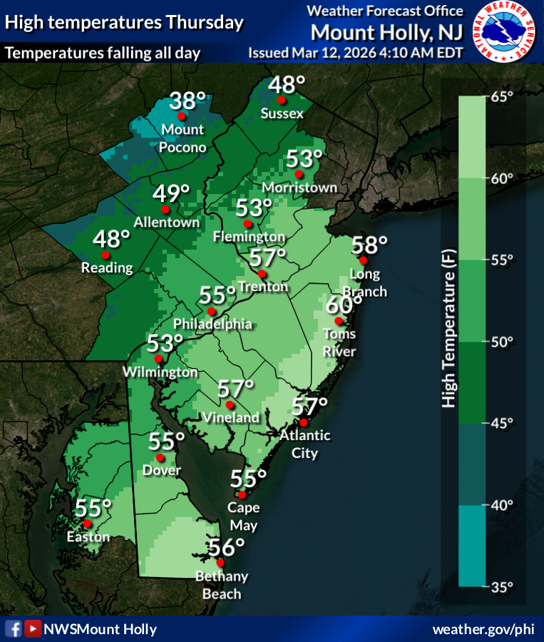
Rain will continue Thursday as the cold front continues to sweep through the region, with temperatures steadily falling to around 35 degrees by 5 p.m.
That precipitation will then shift to snow at some point in the late afternoon or early evening, the National Weather Service said.
Find out what's happening in Across Pennsylvaniafor free with the latest updates from Patch.
Strong wind will also remain in the area a day after the thunderstorms, with steady winds up to 20 miles per hour and gusts up to 40 miles per hour in more outlying areas.
Significant accumulation is not currently expected.
Find out what's happening in Across Pennsylvaniafor free with the latest updates from Patch.
"Where winter storms occur, the strength of the March sun may limit snow accumulation on roads and sidewalks during the middle of the day," Accuweather said. "However, at night and during the morning commute, as surfaces cool and snow falls steadily, travel could become slippery."
After the near record heat earlier this week, this cold front will bring in cooler weather for a few days. The low will drop to 40 on Friday night and 38 on Saturday night, with steady winds making for a potentially frigid wind chill.
Accuweather meteorologists believe the rapid shift to cooler weather is due to another break in the polar vortex, which is due to sudden warming in the stratosphere. It's occurred numerous times this winter and could occur again in early April, they said.
Here's the full forecast for the coming week in the Philadelphia area, according to the National Weather Service:
Thursday
Rain. Temperature falling to around 35 by 5 p.m. Breezy, with a northwest wind 15 to 20 mph, with gusts as high as 35 mph. Chance of precipitation is 90 percent. New precipitation amounts between a tenth and quarter of an inch possible.
Thursday Night
A chance of rain and snow before 7 p.m. Mostly cloudy during the early evening, then gradual clearing, with a low around 31. Northwest wind 5 to 10 mph. Chance of precipitation is 30 percent. Little or no snow accumulation expected.
Friday
Sunny through mid morning, then becoming partly sunny, with a high near 51. Light south wind increasing to 10 to 15 mph in the morning. Winds could gust as high as 30 mph.
Friday Night
Mostly clear, with a low around 40. South wind around 10 mph, with gusts as high as 25 mph.
Saturday
Sunny, with a high near 53. West wind around 10 mph, with gusts as high as 20 mph.
Saturday Night
Mostly cloudy, with a low around 38.
Sunday
Cloudy, with a high near 56.
Sunday Night
Rain, mainly after 2 a.m. Low around 49. Chance of precipitation is 80 percent.
Monday
Rain. High near 66. Chance of precipitation is 90 percent.
Monday Night
Rain likely before 2 a.m. Mostly cloudy, with a low around 32. Chance of precipitation is 60 percent.
Tuesday
Mostly sunny, with a high near 40.
Tuesday Night
Mostly clear, with a low around 25.
Wednesday
Sunny, with a high near 41.
Get more local news delivered straight to your inbox. Sign up for free Patch newsletters and alerts.