Weather
Tropical Storm Chantal Remnants To Dump Up To 5 Inches Of Rain On PA
Localized torrential rain could swell waterways and lead to flash flooding through the region.

After sweeping up the Atlantic coast and causing floods and damage in the south, the remnants of Tropical Storm Chantal are expected to hammer the greater Philadelphia area over the coming days, forecasters said.
Up to five inches of rain could fall Monday as part of a severe weather front that threatens the region with flash flooding. Remnants of Chantal could be felt through Wednesday.
The National Weather Service has issued a Flood Watch in all of southeastern Pennsylvania until 10 p.m. Monday.
Find out what's happening in Across Pennsylvaniafor free with the latest updates from Patch.
"The remnants of Chantal will move into the Mid Atlantic this morning bringing areas of heavy rain," National Weather Service forecasters said. "The tropical airmass will bring generally 1 to 2 inches of rainfall across the urban corridor but will have the potential to bring isolated amounts up to 5 inches leading to flash flooding."
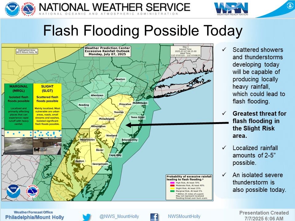
Forecasters say that the immediate Philadelphia area, including the five-county area in Pennsylvania along with parts of south Jersey and Delaware, is squat in the middle of the highest risk zone.
Find out what's happening in Across Pennsylvaniafor free with the latest updates from Patch.
Some scattered thunderstorms and showers are possible in the late morning and early afternoon, but the bulk of the storm will arrive after 1 p.m. It's expected to continue until around 8 p.m.
Tuesday could be even worse, as the National Weather Service says Tuesday has the "greatest potential for widespread showers and thunderstorms." Chances of storms will increase throughout the day, with showers likely from 2 p.m. to 5 p.m. and then heavy rainfall likely after 5 p.m.
In between the storms this week will be hot and muggy, with highs in the upper 80s to low 90s through Wednesday.
Here's the full forecast for this week, according to the National Weather Service:
Monday
A chance of showers before 11 a.m., then a chance of showers and thunderstorms between 11 a.m. and 1 p.m., then showers likely and possibly a thunderstorm after 1 p.m. Some of the storms could produce heavy rainfall. Mostly cloudy, with a high near 89. South wind around 5 mph. Chance of precipitation is 70 percent. New rainfall amounts between a half and three quarters of an inch possible.
Monday Night
Showers and thunderstorms likely, mainly before 8 p.m. Some of the storms could produce heavy rainfall. Mostly cloudy, then gradually becoming mostly clear, with a low around 75. Southeast wind around 5 mph becoming calm. Chance of precipitation is 60 percent. New precipitation amounts between a quarter and half of an inch possible.
Tuesday
Showers likely and possibly a thunderstorm between 2 p.m. and 5 p.m., then showers and thunderstorms likely after 5 p.m. Some of the storms could produce heavy rainfall. Increasing clouds, with a high near 94. Heat index values as high as 101. Southwest wind 5 to 10 mph. Chance of precipitation is 60 percent. New rainfall amounts between a tenth and quarter of an inch, except higher amounts possible in thunderstorms.
Tuesday Night
Showers and thunderstorms likely before 5 a.m., then a chance of showers. Some of the storms could produce heavy rainfall. Mostly cloudy, with a low around 74. West wind around 5 mph becoming calm in the evening. Chance of precipitation is 60 percent. New rainfall amounts between a half and three quarters of an inch possible.
Wednesday
A chance of showers, with thunderstorms also possible after 11 a.m. Partly sunny, with a high near 88. Calm wind becoming southwest around 5 mph in the afternoon. Chance of precipitation is 50 percent. New rainfall amounts of less than a tenth of an inch, except higher amounts possible in thunderstorms.
Wednesday Night
A chance of showers and thunderstorms. Mostly cloudy, with a low around 72. Chance of precipitation is 50 percent. New rainfall amounts between a quarter and half of an inch possible.
Thursday
A chance of showers, then showers likely and possibly a thunderstorm after 2 p.m. Cloudy, with a high near 84. Chance of precipitation is 70 percent.
Thursday Night
Showers likely and possibly a thunderstorm before 2 a.m., then a chance of showers. Cloudy, with a low around 71. Chance of precipitation is 60 percent
Friday
A chance of showers, with thunderstorms also possible after 2 p.m. Mostly cloudy, with a high near 82. Chance of precipitation is 50 percent.
Friday Night
A chance of showers and thunderstorms. Mostly cloudy, with a low around 71. Chance of precipitation is 30 percent.
Saturday
A chance of showers and thunderstorms. Partly sunny, with a high near 84. Chance of precipitation is 40 percent.
Saturday Night
A chance of showers and thunderstorms. Mostly cloudy, with a low around 71. Chance of precipitation is 30 percent.
Sunday
A chance of showers and thunderstorms. Partly sunny, with a high near 85. Chance of precipitation is 50 percent.
Get more local news delivered straight to your inbox. Sign up for free Patch newsletters and alerts.


