Weather
'Very Heavy' Rain Could Slam Philly Region As Heat Breaks
The storm front will end the oppressive heat wave, but flooding is possible, forecasters said. Details:

The extreme heat wave in the greater Philadelphia region that brought multiple days of record-breaking heat is finally over, but it's being pushed out by a strong storm system that could bring rounds of "very heavy" rain and potentially damaging flooding to the area, forecasters said.
Rain and scattered thunderstorms are likely to arrive after 2 p.m., according to the National Weather Service.
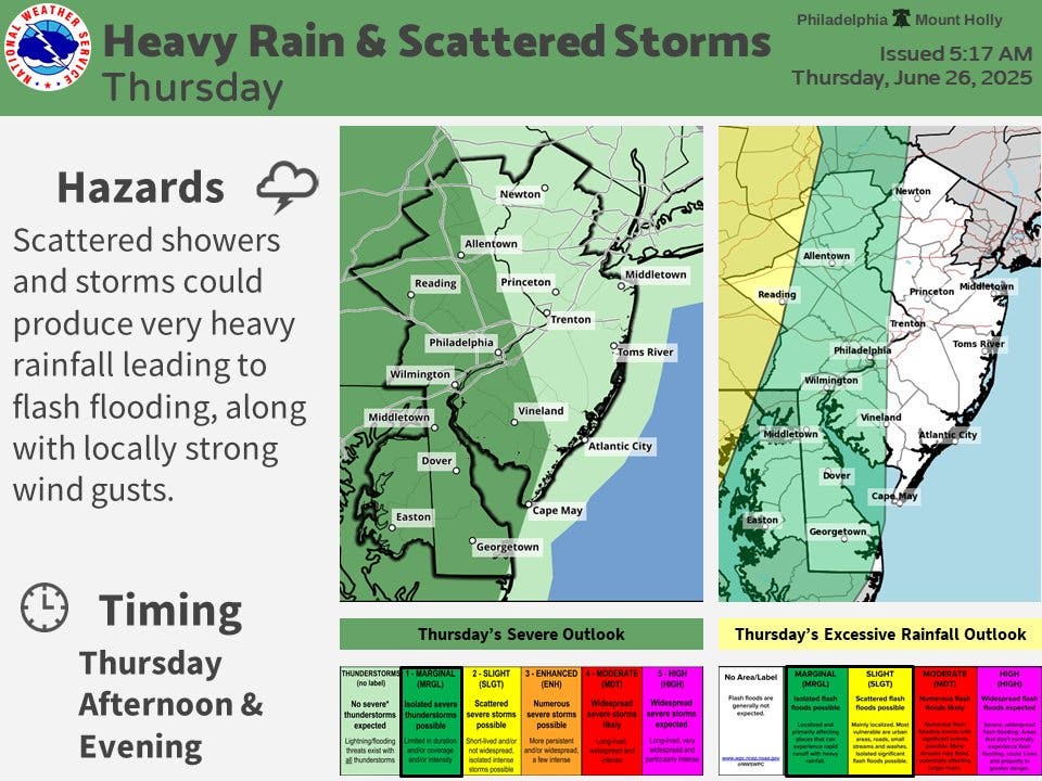
The agency categorizes most of eastern Pennsylvania as being within the "marginal" risk for excessive rainfall and severe thunder.
Find out what's happening in Across Pennsylvaniafor free with the latest updates from Patch.
In addition to flash flooding, powerful wind gusts could also hit the region. Temperatures will be cooler where the storm hits, but humidity will be high and in locations where there is less rainfall, the heat index will remain high.
"A backdoor cold front will be moving through today, providing relief to the heat for some, but not all," the National Weather Service's Mt. Holly, New Jersey branch shared.
Find out what's happening in Across Pennsylvaniafor free with the latest updates from Patch.
The cooling effect by the storms will be pronounced.
"This can dramatically drop temperatures by 20-40 degrees in some cases, which is about as big as it gets this time of the year," Accuweather Senior Meteorologist Brett Anderson said.
Here's the full forecast, according to the National Weather Service:
Thursday
Scattered showers and thunderstorms after 2 p.m. Partly sunny, with a high near 90. Northeast wind around 10 mph. Chance of precipitation is 40 percent. New rainfall amounts of less than a tenth of an inch, except higher amounts possible in thunderstorms.
Thursday Night
A chance of showers and thunderstorms, mainly after 1 a.m. Mostly cloudy, with a low around 66. Northeast wind 10 to 15 mph. Chance of precipitation is 50 percent. New rainfall amounts between a tenth and quarter of an inch, except higher amounts possible in thunderstorms.
Friday
A slight chance of showers before 2 p.m., then a slight chance of showers and thunderstorms after 3 p.m. Cloudy, with a high near 73. East wind around 10 mph, with gusts as high as 20 mph. Chance of precipitation is 20 percent.
Friday Night
A chance of showers and thunderstorms. Cloudy, with a low around 68. East wind around 5 mph becoming calm after midnight. Chance of precipitation is 30 percent. New rainfall amounts of less than a tenth of an inch, except higher amounts possible in thunderstorms.
Saturday
A chance of showers and thunderstorms after 2 p.m. Partly sunny, with a high near 88. Calm wind becoming southwest around 5 mph in the afternoon. Chance of precipitation is 50 percent. New rainfall amounts of less than a tenth of an inch, except higher amounts possible in thunderstorms.
Saturday Night
A chance of showers and thunderstorms before 2 a.m., then a slight chance of showers. Mostly cloudy, with a low around 73. Chance of precipitation is 40 percent. New rainfall amounts between a tenth and quarter of an inch, except higher amounts possible in thunderstorms.
Sunday
A chance of showers after 2 p.m. Partly sunny, with a high near 84. Chance of precipitation is 40 percent.
Sunday Night
A chance of showers before 8 p.m. Partly cloudy, with a low around 70. Chance of precipitation is 30 percent.
Get more local news delivered straight to your inbox. Sign up for free Patch newsletters and alerts.