Weather
Rainy, Wintry Weather To Hit Philly Area In Abrupt Shift: Forecasters
Rain followed by wind and a sudden cold front could plunge wind chills into the single digits, forecasters said.


EASTERN PA — Remnants of winter will spill over into April this week in the greater Philadelphia region, bringing rain, high winds, and potentially a wintry mix in some areas, according to forecasters. It brings an abrupt end to a string of balmy temperatures throughout the region that appeared to harken the start of spring.
Periods of rain will continue throughout the day Monday and into the evening. It's possible that this could turn to freezing rain or even snow flurries in some areas, although that is likely to be restricted to regions north of the five-county area, in the lower Poconos, the National Weather Service said.
A total of half an inch of precipitation could fall in southeastern Pennsylvania Monday.
Find out what's happening in Across Pennsylvaniafor free with the latest updates from Patch.
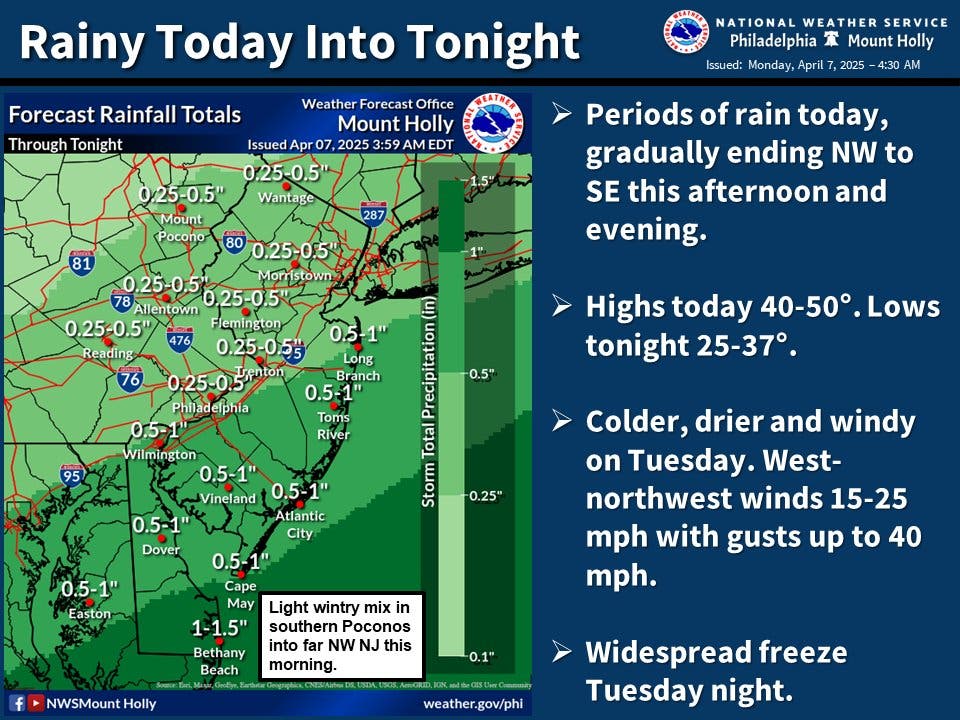
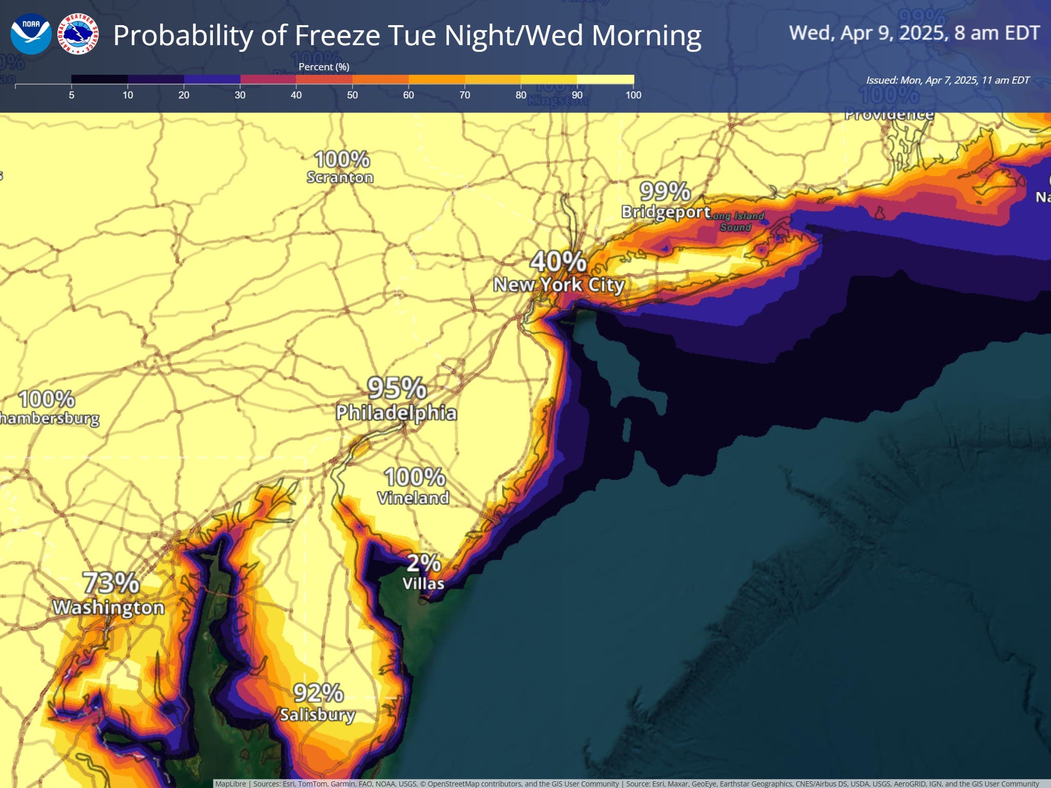
A significant cold front will come through following the rain, plummeting temperatures into the lower 30s and upper 20s overnight, according to forecasters.
Find out what's happening in Across Pennsylvaniafor free with the latest updates from Patch.
"It will feel like winter for many across the midwest and northeast at the start of the week as Arctic air surges south from Canada," AccuWeather meteorologist Alex DaSilva said. "Temperatures across much of the midwest and interior northeast will be as much as 10-20 degrees (Fahrenheit) below the historical average, and with a gusty wind out of the northwest conditions will feel very chilly."
For those who have already planted crops or home gardens, forecasters warn that steps to protect your plants should be considered, as a freeze is almost certain.
Winds will pickup with the cold on Tuesday, with sustained wind of 15 to 25 miles per hour, and gusts up to 40 miles per hour, possible throughout the Philly region.
Because of the combination of wind and low temperatures with the coming cold front, the wind chill and actual feel of the air outside could plummet down to the single digits in some areas, Accuweather adds.
While clear conditions will accompany the colder weather on Tuesday and Wednesday, rain is likely to return by Thursday, with the possibility of showers continuing through Friday evening, the National Weather Service says.
Here's the full forecast, according to the National Weather Service:
Monday
Rain likely before 2 p.m., then a chance of showers after 2 p.m. Cloudy, with a high near 48. Northeast wind around 5 mph. Chance of precipitation is 60 percent. New precipitation amounts of less than a tenth of an inch possible.
Monday night
A chance of showers, mainly before midnight. Cloudy, then gradually becoming partly cloudy, with a low around 32. North wind around 5 mph becoming west after midnight. Chance of precipitation is 40 percent. New precipitation amounts of less than a tenth of an inch possible.
Tuesday
Sunny, with a high near 46. Breezy, with a west wind 15 to 20 mph, with gusts as high as 35 mph.
Tuesday night
Mostly clear, with a low around 30. West wind 10 to 15 mph, with gusts as high as 25 mph.
Wednesday
Sunny, with a high near 51. Northwest wind around 10 mph.
Wednesday Night
Partly cloudy, with a low around 37.
Thursday
A chance of rain after 2 p.m. Mostly cloudy, with a high near 57. Chance of precipitation is 30 percent.
Thursday night
Rain likely, mainly after 2 a.m. Mostly cloudy, with a low around 47. Chance of precipitation is 60 percent.
Friday
Rain likely, mainly after 2 p.m. Mostly cloudy, with a high near 61. Chance of precipitation is 60 percent.
Friday night
Rain likely before 2 a.m., then a chance of showers after 2 a.m. Mostly cloudy, with a low around 48. Chance of precipitation is 60 percent.
Get more local news delivered straight to your inbox. Sign up for free Patch newsletters and alerts.


