Weather
PA Winter Storm: 50 MPH Winds, Snow In Eastern PA: Updated Forecast
A powerful winter storm could cause power outages and impact the commute in eastern Pennsylvania this week. Details:


EASTERN PA — A powerful winter storm is on the way to eastern Pennsylvania, with strong winds, frigid temperatures, and the potential for snow accumulation, according to forecasters.
Scattered snow will begin to arrive at some point overnight Wednesday into Thursday, likely after 2 a.m., forecasters said. A Wind Advisory has been issued for the entire region and isolated power outages are possible.
"Some snow showers may result in some light accumulation and a slippery commute for Thursday morning," the National Weather Service's Mt. Holly, New Jersey branch shared.
Find out what's happening in Across Pennsylvaniafor free with the latest updates from Patch.
Snow may continue throughout the morning, up until around 10 a.m., and up to half an inch of snow could accumulate in the greater Philadelphia area. Greater accumulation is expected in the north, and the Poconos could receive up to two to three inches.
"A brief coating of snow lasting only a few minutes before melting on bridges and overpasses can be enough to create dangerous conditions for the Thursday morning commute," AccuWeather said.
Find out what's happening in Across Pennsylvaniafor free with the latest updates from Patch.
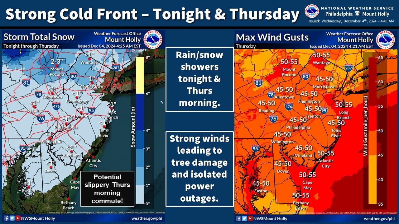
While the snow will make roads slippery, the greater impact could be from the wind. Steady breezes of 30 miles per hour and gusts up to 55 miles per hour are forecasted, prompting a Wind Advisory.
"Tree damage and isolated power outages are possible," the National Weather Service added. "Take the time today to secure an lose outdoor items such as trash cans, holiday decorations, patio furniture, etc."
Temperatures, meanwhile, will plummet again into the 20s overnight, with wind gusts up to 45 miles per hour persisting and making for dangerous wind chills.
Here's the full forecast:
Wednesday: Mostly cloudy, with a high near 41. South wind 5 to 15 mph.
Wednesday Night: A chance of rain and snow showers, mainly after 2 a.m. Mostly cloudy, with a low around 38. Breezy, with a southwest wind 15 to 20 mph. Chance of precipitation is 40 percent. Little or no snow accumulation expected.
Thursday: A chance of rain and snow showers before 8am, then a chance of snow showers between 8am and 10 a.m. Mostly sunny, with a high near 39. Windy, with a west wind 20 to 30 mph, with gusts as high as 50 mph. Chance of precipitation is 50 percent. New snow accumulation of less than a half inch possible.
Thursday Night: Mostly clear, with a low around 28. Breezy, with a west wind 15 to 25 mph, with gusts as high as 45 mph.
Friday: Sunny, with a high near 36. Breezy, with a northwest wind 15 to 20 mph, with gusts as high as 30 mph.
Friday Night: Mostly clear, with a low around 26.
Saturday: Mostly sunny, with a high near 39.
Saturday Night: Partly cloudy, with a low around 28.
Sunday: Sunny, with a high near 48.
Sunday Night: Partly cloudy, with a low around 35.
Monday: Rain likely. Mostly cloudy, with a high near 53. Chance of precipitation is 60 percent.
Monday Night: Rain likely. Mostly cloudy, with a low around 44. Chance of precipitation is 70 percent.
Tuesday: A chance of rain. Mostly cloudy, with a high near 60. Chance of precipitation is 50 percent.
Get more local news delivered straight to your inbox. Sign up for free Patch newsletters and alerts.


