Weather
'Accumulating' Snow Possible Friday, Hazardous Weather Outlook Issued
Forecasters say there is now a 70 percent chance we will get accumulating snow early Friday.

A Hazardous Weather Outlook has been issued across the Philadelphia region due to the possibility of accumulating snow later this week.
The National Weather Service says there is a chance of accumulating snow Thursday night into Friday morning, with 1 to 4 inches possible across the region. The heaviest snow will fall during the Friday morning commute, the NWS predicts.
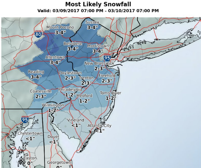
Forecasters with the NWS say the chance of precipitation is now 70 percent.
Find out what's happening in Doylestownfor free with the latest updates from Patch.
Rain and snow are possible before 11 a.m. on Friday, then precipitation will likely turn to all rain during the day, with another chance of snow possible after 5 p.m.
The Hazardous Weather Outlook has been issued in Bucks, Chester, Delaware, Montgomery and Philadelphia counties, as well as in Carbon, Monroe, Berks, Lehigh and Northampton.
Find out what's happening in Doylestownfor free with the latest updates from Patch.
The chance of snow follows mild temperatures mid-week. Wednesday's high is expected to climb into the 60s. Temperatures during the day Thursday will be in the 50s, but cold will move in at night. Highs on Friday will be in the upper 30s, the NWS predicts.
The weekend will be cold, with temperatures in the low 30s Saturday and mid 30s Sunday.
Additionally, the NWS is warning of isolated wind gusts up to 45 mph on Wednesday. "There is an enhanced risk for Fire weather concern," the NWS said.
Here is the forecast:
Today: Sunny, with a high near 61. Breezy, with a west wind 10 to 20 mph, with gusts as high as 38 mph.
Tonight: Mostly clear, with a low around 41. West wind 10 to 13 mph.
Thursday: Mostly sunny, with a high near 55. West wind 11 to 16 mph.
Thursday Night: A chance of rain after 9pm, mixing with snow after 4am. Mostly cloudy, with a low around 32. West wind 5 to 7 mph becoming north after midnight. Chance of precipitation is 50%. Little or no snow accumulation expected.
Friday: Rain and snow likely before 11am, then rain likely between 11am and 5pm, then rain and snow likely after 5pm. Mostly cloudy, with a high near 39. North wind 6 to 10 mph becoming northwest in the afternoon. Chance of precipitation is 70%. New snow accumulation of 1 to 2 inches possible.
Friday Night: A slight chance of rain and snow showers before 7pm, then a slight chance of snow showers between 7pm and 8pm. Partly cloudy, with a low around 19. Chance of precipitation is 20%.
Saturday: Mostly sunny, with a high near 31.
Saturday Night: Mostly cloudy, with a low around 19.
Sunday: Partly sunny, with a high near 34.
Get more local news delivered straight to your inbox. Sign up for free Patch newsletters and alerts.