Weather
Tropical Storm Hermine Leads to Hazardous Weather Outlook In PA
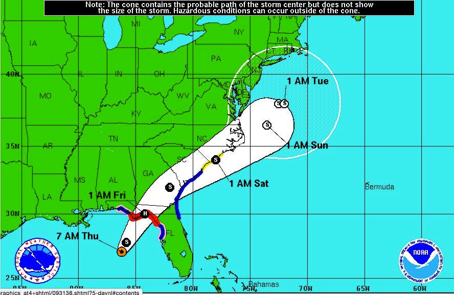
A hazardous weather outlook has been issued in PA for Tropical Storm Hermine, which is expected to become a hurricane when it hits land.

A hazardous weather outlook has been issued in Eastern Pennsylvania for Tropical Storm Hermine, which is expected to become a hurricane when it makes landfall this weekend.
The alert was issued for the Philadelphia region, including the following counties: Bucks, Chester, Delaware, Montgomery, Philadelphia, Lehigh and Northampton.
The storm, currently located over the Gulf of Mexico, is expected to move north toward the mid-Atlantic region this weekend, bringing heavy rain and gusty winds, according to the National Weather Service.
Find out what's happening in Doylestownfor free with the latest updates from Patch.
The storm is expected to become a hurricane, bringing winds exceeding 70 mph, when it hits Florida this weekend. But wind speeds will be half that if Hermine gets here, reducing it to a tropical storm, forecasters predict.
The storm also brings a renewed threat of rip currents through the busy Labor Day weekend. Beachgoers are being told that they should enter the water only if lifeguards are present, according to a briefing package put together by the National Weather Service.
Find out what's happening in Doylestownfor free with the latest updates from Patch.
Read more: Tropical Storm Hermine Intensifies On Way to Florida's Gulf Coast
Most rip current deaths occur on beaches when and where no life guards are on duty. Beach erosion is also possible, according to the briefing.
The actual impacts remain uncertain, and depend on the track and strength of the storm.
The storms could also bring these elements to the region:
- Strong Winds: There is a chance for tropical storm force winds - 39 to 73 mph - this Labor Day weekend as Tropical Storm Hermine, or its remnants, move north.
- The strongest winds should occur Saturday and Sunday. An inland path would result in lower winds.
- Heavy rain: There is a risk for heavy rain over much of the mid-Atlantic area. However, specific rainfall amounts are highly dependent on the eventual track of the storm. Recent dry weather will lessen the severity of any stream and river flooding that may develop.
- Street flooding and flash flooding are greater threats.
- Storm surge: It is still too early to determine if storm surge will occur with Hermine. A inland path would lessen the threat from surge. However, astronomical tides will be running high from the new moon on Sept. 1, so less onshore flow is needed for coastal flooding to develop.
- Timing: The second round of increased rip current risk (from Hermine) could begin Friday, then persist through Monday (Labor Day).
- Strong winds and heavy rain are most likely Saturday and Sunday, with showers possibly lingering into Monday.
Here is the forecast for the region:
Thursday: Showers, with thunderstorms also possible after 4 p.m. High near 80. North wind around 5 mph. Chance of precipitation is 80 percent. New rainfall amounts between a 10th and quarter of an inch, except higher amounts possible in thunderstorms.
Thursday night: A chance of showers and thunderstorms before 8 p.m., then a slight chance of showers between 8 p.m. and 10 p.m. Mostly cloudy, then gradually becoming mostly clear, with a low around 62. Light north wind increasing to 5 to 9 mph in the evening. Chance of precipitation is 30 percent. New precipitation amounts between a tenth and quarter of an inch, except higher amounts possible in thunderstorms.
Friday: Sunny, with a high near 79. North wind around 9 mph.
Friday night: Partly cloudy, with a low around 61. Northeast wind 5 to 7 mph.
Saturday: A chance of rain after noon. Partly sunny, with a high near 77. East wind 11 to 17 mph. Chance of precipitation is 30 percent. New precipitation amounts of less than a tenth of an inch possible.
Saturday night: A chance of rain. Mostly cloudy, with a low around 61. Chance of precipitation is 40 percent. New precipitation amounts of less than a tenth of an inch possible.
Sunday: A chance of rain. Partly sunny, with a high near 75. Breezy. Chance of precipitation is 40%.
Sunday night: A chance of rain. Mostly cloudy, with a low around 62. Breezy. Chance of precipitation is 30 percent.
Labor Day: Partly sunny, with a high near 80.
Monday night: Partly cloudy, with a low around 63.
Photos: National Weather Service
Get more local news delivered straight to your inbox. Sign up for free Patch newsletters and alerts.