Weather
Thunderstorms Ahead For Philly Area: Latest Forecast
Forecasters are expecting a cold front to start slipping southward into the region during the day on Wednesday bringing showers and storms.

PHILADELPHIA, PA — After two days of near to record warmth, a cold front is forecast to approach the Philadelphia region on Wednesday, bringing with it a chance of showers, thunderstorms and a 20 to 30 degree drop in temperatures.
Forecasters are expecting the front to "start slipping southward" into the region during the day on Wednesday, and that will make the temperature forecast "tricky."
Southern locales in the Delmarva have a good shot at ending up warmer on Wednesday than Tuesday, while near Philly the odds are closer to 50-50, and up by the Lehigh Valley and northern New Jersey, the odds favor Tuesday being warmer than Wednesday, said forecasters with the National Weather Service in Mount Holly, New Jersey.
Find out what's happening in Doylestownfor free with the latest updates from Patch.
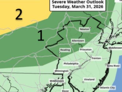
Showers and storms may arrive from the northwest on Wednesday mainly in the afternoon and evening, but forecasters say the odds of severe weather are looking mediocre. "We have just a little area of marginal risk across mainly the western zones for Wednesday."
Forecasters are expecting the cold front to stall across the region on Thursday with a stretch of unsettled weather leading into the Easter holiday weekend.
Find out what's happening in Doylestownfor free with the latest updates from Patch.
"It will try to move north as a warm front, but will struggle with a high pressure system to the north ushering in cooler air," said forecasters. "The locations north of the front, highs on Thursday will be in the 40s to mid 50s. Area south of the front will be in the upper 50s to upper 60s."
Forecasters said there will be plenty of clouds on Thursday due to the front being nearby. Overall, the day looks pretty dry with the chance of some isolated rain showers, they said.
Here's the full forecast for the Philadelphia area for the coming few days, according to the National Weather Service:
Wednesday
A slight chance of showers before 11 a.m., then a slight chance of showers and thunderstorms between 11 a.m. and 2 p.m., then showers likely and possibly a thunderstorm after 2 p.m. Mostly cloudy, with a high near 77. Southwest wind around 10 mph, with gusts as high as 20 mph. Chance of precipitation is 70 percent. New rainfall amounts of less than a tenth of an inch, except higher amounts possible in thunderstorms.
Wednesday Night
Showers and possibly a thunderstorm before 2 a.m., then a chance of showers. Low around 47. Southeast wind 5 to 10 mph becoming northeast after midnight. Chance of precipitation is 80 percent. New rainfall amounts between a quarter and half of an inch possible.
Thursday
A chance of showers. Cloudy, with a high near 51. East wind around 10 mph. Chance of precipitation is 30 percent. New precipitation amounts of less than a tenth of an inch possible.
Thursday Night
A chance of showers before 2 a.m. Cloudy, with a low around 44. Chance of precipitation is 30 percent.
Friday
Mostly cloudy, with a high near 71.
Friday Night
Mostly cloudy, with a low around 56
Get more local news delivered straight to your inbox. Sign up for free Patch newsletters and alerts.