Weather
Severe Thunderstorm Watch Called Across Eastern PA
A severe thunderstorm watch is now in effect across Eastern Pennsylvania.


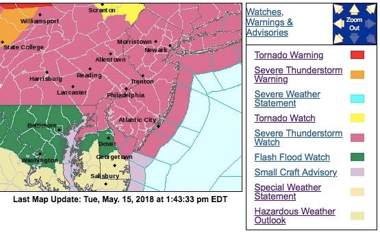
A severe thunderstorm watch is now in effect across Eastern Pennsylvania. Ten counties in Pennsylvania are included and residents there should be mindful of the potential for severe weather during the evening hours, the National Weather Service warns.
The counties included in the severe thunderstorm watch include Berks, Bucks, Carbon, Chester, Delaware, Lehigh, Monroe, Montgomery, Northampton and Philadelphia.
The storms are expected to move through the area around the time of the evening commute. Drivers should be prepared for torrential downpours and potential flooding as the storms move through.
Find out what's happening in Doylestownfor free with the latest updates from Patch.
The storms could also bring strong winds and large hail, the NWS said. A flash flood watch is also in place from 4 p.m. Tuesday through 2 a.m. Wednesday morning.
The severe thunderstorm watch is in effect until 11 p.m. Here are the alerted areas:
Find out what's happening in Doylestownfor free with the latest updates from Patch.
Forecasters say a line of intense thunderstorms is expected to move into the region from the northwest late this afternoon and into the evening. "There are indications that storms may repeatedly move over the same areas, especially during the evening hours. Localized rainfall of one to three inches is likely where this occurs," the NWS said.
Combined with the rainfall we got this past weekend, this may lead to a flash flooding in some areas, forecasters warn.
The storms are expected to move through the area around the time of the evening commute. Drivers should be prepared for torrential downpours and potential flooding as the storms move through.
Is Your Dog The Best? Enter Patch's Top Dog In Philly Contest
It is also Primary Election Day. Make sure you plan accordingly and bring an umbrella out to your polling place if you plan to go after work.
Unfortunately this won't be the last of the rain. There is a chance of showers and thunderstorms in the forecast everyday through early next week.
Here is the forecast:
Today: Showers and thunderstorms, mainly after 5pm. Some of the storms could be severe. High near 88. Southwest wind 7 to 13 mph. Chance of precipitation is 80%. New rainfall amounts between a quarter and half of an inch possible.
Tonight: Showers and thunderstorms, mainly before 11pm. Some storms could be severe, with damaging winds and heavy rain. Low around 63. Light and variable wind becoming northeast 5 to 7 mph after midnight. Chance of precipitation is 80%. New rainfall amounts between a quarter and half of an inch possible.
Wednesday: A chance of showers and thunderstorms before 8am, then a chance of showers between 8am and 2pm, then showers likely and possibly a thunderstorm after 2pm. Cloudy, with a high near 69. East wind 6 to 9 mph. Chance of precipitation is 60%. New rainfall amounts between a tenth and quarter of an inch, except higher amounts possible in thunderstorms.
Wednesday night: Showers likely and possibly a thunderstorm before 8pm, then a chance of showers. Patchy fog. Otherwise, cloudy, with a low around 56. East wind around 6 mph becoming calm in the evening. Chance of precipitation is 60%. New precipitation amounts of less than a tenth of an inch, except higher amounts possible in thunderstorms.
Thursday: A chance of showers. Cloudy, with a high near 74. Northeast wind 3 to 6 mph. Chance of precipitation is 40%. New precipitation amounts of less than a tenth of an inch possible.
Thursday night: Showers likely and possibly a thunderstorm. Patchy fog after 2am. Otherwise, cloudy, with a low around 58. Chance of precipitation is 70%. New rainfall amounts between a quarter and half of an inch possible.
Friday: Showers. Patchy fog before 8am. High near 64. Chance of precipitation is 80%.
Friday night: Showers. Patchy fog. Low around 55. Chance of precipitation is 80%.
Saturday: Showers likely, with thunderstorms also possible after 2pm. Cloudy, with a high near 71. Chance of precipitation is 60%.
Saturday night: A chance of showers and thunderstorms. Cloudy, with a low around 63. Chance of precipitation is 50%.
Sunday: A chance of showers and thunderstorms. Mostly cloudy, with a high near 80. Chance of precipitation is 40%.
Sunday night: A chance of showers and thunderstorms. Mostly cloudy, with a low around 64. Chance of precipitation is 30%.
Monday: A chance of showers. Mostly cloudy, with a high near 79. Chance of precipitation is 40%.
Image via Shutterstock
Get more local news delivered straight to your inbox. Sign up for free Patch newsletters and alerts.