Weather
Timing, Latest Snowfall Estimates For Tonight's Storm In PA
A winter storm warning has been issued. Here's what you can expect in terms of timing and likely snowfall accumulation for Eastern PA.


The threat level for Sunday's storm has been upgraded to a Winter Storm Warning in Eastern Pennsylvania.
The Winter Storm Warning from the National Weather Service is in effect from 3 p.m. Sunday to 7 a.m. Monday. Heavy snow is predicted, with seven inches expected throughout the region, according to the NWS.
The storm will begin as rain this afternoon and will turn to all snow by the evening. Snow could fall heavy at times — at up to an inch per hour. Snow will end early Monday morning.
Find out what's happening in Doylestownfor free with the latest updates from Patch.
"While the snow will end before the Monday morning commute, hazardous conditions should still be occurring from the earlier heavy snow," the NWS said.
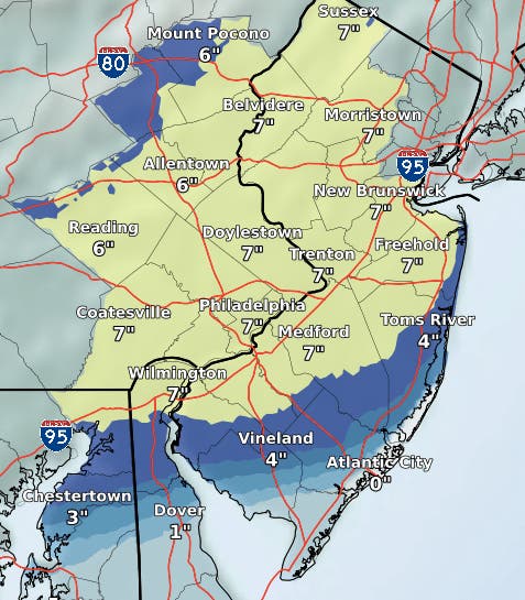
Here is the NWS map of predicted snowfall totals as of Sunday morning:
Find out what's happening in Doylestownfor free with the latest updates from Patch.
The Weather Channel is predicting lower accumulation totals, saying three to five inches of snow is expected.
The Weather Channel predicts the rain will start around 3 p.m. Sunday, with the switchover coming around 6 p.m. Snow is expected to stop around 3 a.m.
The forecast for the rest of the week shows a break from the snow, but not the cold. Wednesday's high is 26 degrees. The low temperature on Wednesday will be in the single digits.
Here is the forecast:
Today: Rain, mainly after 3pm. High near 41. Light and variable wind. Chance of precipitation is 90%. New precipitation amounts between a tenth and quarter of an inch possible.
Tonight: Snow, mainly before 4am. Low around 31. Light and variable wind becoming north 5 to 9 mph in the evening. Chance of precipitation is 100%. New snow accumulation of 3 to 7 inches possible.
Monday: Cloudy, then gradually becoming mostly sunny, with a high near 36. Northwest wind 9 to 13 mph.
Monday Night: Mostly clear, with a low around 14. West wind 5 to 9 mph.
Tuesday: Sunny, with a high near 30. West wind 5 to 9 mph.
Tuesday Night: Partly cloudy, with a low around 13.
Wednesday: Mostly sunny, with a high near 26.
Wednesday Night: Partly cloudy, with a low around 8.
Thursday: Sunny, with a high near 31.
Thursday Night: Partly cloudy, with a low around 17.
Get more local news delivered straight to your inbox. Sign up for free Patch newsletters and alerts.