Weather
Tropical Storm Gordon Remnants Headed To PA, Flooding Possible
The remnants of the storm are expected to hit Eastern PA on Sunday or Monday, with up to 4 inches of rain possible in some areas.


As peak hurricane season approaches, Eastern Pennsylvania could get drenched by the remnants of Tropical Storm Gordon, forecasters say. Plus, meteorologists are watching another storm making its way across the Atlantic.
Tropical Storm Gordon made landfall in Mississippi Tuesday night, battering the area with heavy rain and brutal winds. It's expected to make its way north and east. Though it will be greatly weakened, the remnants of the storm are expected to hit the northeast on Sunday or Monday, with up to four inches of rain possible in some areas within a 12 to 24 hour period, AccuWeather said.
According to AccuWeather, parts of Eastern Pennsylvania could be hit hard by the rains.
Find out what's happening in Doylestownfor free with the latest updates from Patch.
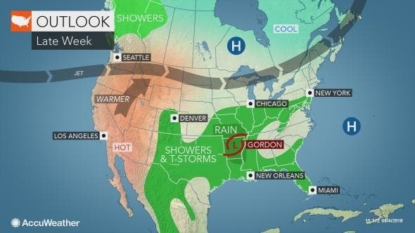
KDKA, which says Pennsylvania is "right in the crosshairs" of the Gordon remnants, estimates as much as five inches of rain could fall across the southern half of Pennsylvania from Sunday to Monday.
Here are the rainfall projections from KDKA:
Find out what's happening in Doylestownfor free with the latest updates from Patch.
Meanwhile, forecasters are predicting unsettled weather from Wednesday evening through the weekend. Several rounds of thunderstorms are possible, the National Weather Service said. A hazardous weather outlook has been issued starting Thursday, the NWS said.
"There is a chance for heavy rainfall and localized flooding with one or more rounds of storms Thursday through the weekend," the NWS said in the hazardous weather outlook.
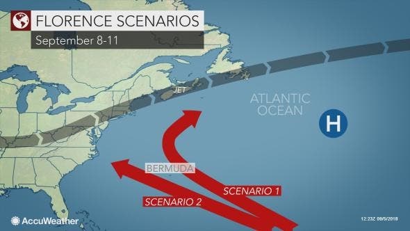
The other storm forecasters are watching is Hurricane Florence, which was upgraded to a category 3 storm on Wednesday morning. Though not near land as of Wednesday, it could be headed towards Bermuda and, from there, possibly towards the Northeast, according to AccuWeather.
"There is concern that Florence may get steered closer to Bermuda around Monday, Sept. 10 — the peak of hurricane season in the Atlantic," AccuWeather meteorologist Kristina Pydynowski said in a release.
"After nearing Bermuda, Florence may attempt to approach the eastern United States later that week," though Pydynowski added it was far too early to accurately predict the storm's path.
While Florence is forecast to fluctuate in strength, most scenarios bring the system close enough to the Atlantic coast of the U.S. and Canada to pester fishing, shipping and coastal interests with rough seas and surf starting this weekend, according to AccuWeather.
There is the scenario that Florence does not turn away before reaching the U.S. Atlantic coast and makes landfall with impacts of a powerful hurricane, according to AccuWeather.
Mid-September is considered the height of the Atlantic hurricane season, and forecasters expect activity to pick up this week.
"At this point of the hurricane season, ocean water temperatures in the tropical Atlantic are at their warmest point, while disturbances, known as tropical waves, roll frequently westward off the coast of Africa," AccuWeather meteorologist Alex Sosnowski said in the release.
"Indications are that two to three new tropical systems may bud and develop in the eastern and central Atlantic this weekend into next week."
Here's the forecast, according to the National Weather Service:
This Afternoon: A slight chance of showers and thunderstorms after 3pm. Partly sunny, with a high near 91. South wind around 6 mph. Chance of precipitation is 20%.
Tonight: Partly cloudy, with a low around 73. South wind around 6 mph.
Thursday: A chance of showers and thunderstorms. Mostly sunny, with a high near 91. West wind around 6 mph. Chance of precipitation is 40%. New rainfall amounts of less than a tenth of an inch, except higher amounts possible in thunderstorms.
Thursday Night: A chance of showers and thunderstorms. Mostly cloudy, with a low around 70. North wind 3 to 5 mph. Chance of precipitation is 50%. New rainfall amounts between a tenth and quarter of an inch, except higher amounts possible in thunderstorms.
Friday: A chance of showers and thunderstorms. Mostly cloudy, with a high near 79. Northeast wind around 6 mph. Chance of precipitation is 40%. New rainfall amounts between a tenth and quarter of an inch, except higher amounts possible in thunderstorms.
Friday Night: A chance of showers and thunderstorms. Cloudy, with a low around 64. Chance of precipitation is 50%. New rainfall amounts between a tenth and quarter of an inch, except higher amounts possible in thunderstorms.
Saturday: A chance of showers and thunderstorms. Mostly cloudy, with a high near 74. Chance of precipitation is 40%.
Saturday Night: A chance of showers. Mostly cloudy, with a low around 61. Chance of precipitation is 30%.
Sunday: A chance of showers, with thunderstorms also possible after noon. Mostly cloudy, with a high near 71. Chance of precipitation is 30%.
Sunday Night: A chance of showers. Mostly cloudy, with a low around 60. Chance of precipitation is 40%.
Monday: A chance of showers and thunderstorms. Mostly cloudy, with a high near 76. Chance of precipitation is 50%.
With reporting by Tom Davis of Patch
In this image provided by NOAA, Tropical Storm Gordon approaches the United States on Tuesday, Sept. 4, 2018. (NOAA via AP)
Get more local news delivered straight to your inbox. Sign up for free Patch newsletters and alerts.