Weather
Updated Snow Estimates, Winter Storm Timing For Eastern PA
Here are the latest snow accumulation estimates and timing for the storm anticipated Tuesday throughout Eastern Pennsylvania.


Meteorologists with the National Weather Service have released updated snowfall accumulation estimates for the storm expected to pass through Tuesday.
Here's the latest forecast:
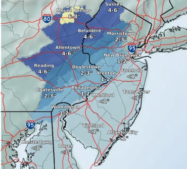
ACCUMULATION
Find out what's happening in Doylestownfor free with the latest updates from Patch.
According to forecasters, snow totals have been lowered since estimates released Monday. The biggest impacts from snowfall will be north and west of the I-95 corridor, including in east central and northeast Pennsylvania, as well as North Jersey.
Other areas can expect rain to turn to snow. "The changeover combined with falling temperatures will create slippery road conditions," the NWS warned.
Find out what's happening in Doylestownfor free with the latest updates from Patch.
Philadelphia and its immediate suburbs can now expect a maximum of two inches. Areas closer to Doylestown and north could get an inch or two more than that, and the Lehigh Valley is looking at about four inches, the NWS said.
Ultimately, snowfall totals will depend on the timing of the change from rain to snow, forecasters said
Here is the latest map:
TIMING
Light flurries have begun falling in some parts of the region. The Weather Channel predicts rain and showers this afternoon, turning to snow around 7 p.m. By 10 p.m., the snow should ease to snow showers, and completely stop by 11 p.m.
The winter precipitation will be followed by some extremely cold temperatures.
THE COLD TO FOLLOW
Arctic air will begin to overspread the region on Wednesday afternoon and evening, possibly accompanied by scattered snow showers and snow squalls, the NWS said.
"Bitterly cold temperatures combined with gusty winds will produce dangerous wind chills below zero Wednesday night and Thursday," the NWS warned.
The coldest wind chills could drop below -20 degrees across the Poconos. There will be a heightened risk for hypothermia and frostbite, authorities warn.
Image via NWS
Get more local news delivered straight to your inbox. Sign up for free Patch newsletters and alerts.