Weather
Wild Changes In Eastern PA Weather Forecast This Weekend
There are really no words to describe the severe weather changes in the forecast over the next few days.


Just a few short weeks ago, we were measuring the snow on our back porch. Now you'll be able to walk out there in your bare feet.
For a day or two, maybe.
Forecasters say Eastern Pennsylvania will undergo some wild weather changes the next few days as temperatures are expected to shoot past 80 degrees on Friday. That pleasant climate will continue until Sunday, when more wild changes take place.
Find out what's happening in Doylestownfor free with the latest updates from Patch.
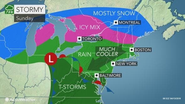
Ironically, Pennsylvania isn't that far away from a snowstorm that will hit upstate New York and New England over the next few days. But, luckily, a warm front from the South will keep the flakes away, according to the National Weather Service.

On Saturday, temperatures will be in the high 70s. Then comes Sunday, when temperatures are supposed to drop 30 degrees overnight to the 40s, according to the National Weather Service.
Find out what's happening in Doylestownfor free with the latest updates from Patch.

Following that could be rain and even thunderstorms possibly on Sunday and almost definitely on Monday that will could make for wet driving conditions for the morning and afternoon commutes.
Here is the local forecast:
Today: Mostly sunny, with a high near 81. Southwest wind 8 to 13 mph. Chance of precipitation is 20%.
Tonight: Mostly clear, with a low around 60. Southwest wind 6 to 11 mph.
Saturday: Sunny, with a high near 78. Southwest wind 9 to 11 mph.
Saturday Night: A chance of showers, mainly between 11pm and 1am, then a chance of showers or drizzle after 1am. Mostly cloudy, with a low around 48. East wind around 14 mph. Chance of precipitation is 30%. New precipitation amounts of less than a tenth of an inch possible.
Sunday: Showers likely with a chance of drizzle before 9am, then showers likely after 9am. Cloudy, with a high near 57. East wind 11 to 15 mph. Chance of precipitation is 70%. New precipitation amounts between a tenth and quarter of an inch possible.
Sunday Night: Rain. Low around 50. Chance of precipitation is 80%. New precipitation amounts between a half and three quarters of an inch possible.
Monday: Rain before 1pm, then showers likely, mainly between 1pm and 5pm. High near 63. Chance of precipitation is 80%.
Monday Night: A chance of showers before 9pm. Mostly cloudy, with a low around 39. Chance of precipitation is 40%.
Tuesday: Partly sunny, with a high near 50.
Image via Shutterstock
With reporting by Tom Davis of Patch
Get more local news delivered straight to your inbox. Sign up for free Patch newsletters and alerts.