Crime & Safety
WEATHER UPDATE: 'Heavy' Snow Threat Looms As Pennsylvania Braces For Storm; Some Schools Close
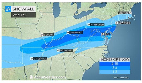
Rain Wednesday will switch over to a "steady, accumulating" snow overnight. As much as 10 inches could fall on the region.


A new storm will spread a swath of snow and sleet spanning more than 1,500 miles, covering much of Pennsylvania, forecasters say.
Daily activities will be affected for close to 100 million people; much of western Pennsylvania was already dealing with flooding on Wednesday. Schools in Pennsylvania were already canceling sessions on Thursday; click here to find out more.
Major travel disruptions are in store, ranging from snow-clogged roads to many flight delays and cancellations. The flight disruptions will likely extend well beyond areas directly affected by the storm as crews and aircraft are displaced.
Find out what's happening in Hatboro-Horshamfor free with the latest updates from Patch.
The new winter storm will occur during a press of cold air invading the Central and Eastern states in the wake a storm that produced snow and ice Tuesday night and rain Wednesday, according to Accuweather.
According to AccuWeather.com Chief Meteorologist Elliot Abrams, in a release: “Usually when cold air follows a storm, the atmosphere just dries out.”
Find out what's happening in Hatboro-Horshamfor free with the latest updates from Patch.
Rain throughout the day Wednesday will switch over to a “steady, accumulating” snow overnight, according to forecasters with the National Weather Service.
Snow accumulations now range from a total of 6 to 10 inches throughout the Philadelphia and South Jersey region, with the heaviest amounts along the I-95 corridor, according to forecasters with NBC10.
Snow will be heavy at times and make travel “very hazardous or impossible,” the NWS said.
Expect heavy snow during the morning rush hour Thursday, the Weather Channel said. Snow will continue throughout the morning and into the afternoon Thursday, forecasters predict.
“Widespread and substantial impacts on travel are expected for late tonight and Thursday,” the Winter Storm Warning said, adding accumulation will be “significant” and travel will be “very hazardous or impossible.”
Milder temperatures Wednesday will give way to sub-freezing temperatures early Thursday. Forecasters with NBC10 say to be prepared for a 20-degree drop from Wednesday to Thursday.
The National Weather Service has issued a “Winter Storm Warning” that will take effect from 7 p.m. Wednesday to 7 p.m. Thursday.
That warning says:
- The bulk of the snow will hit the central and southern portions of the state, according to News12.
- The amount of snow accumulation Wednesday night and Thursday will depend on how quickly the rain changes to snow and if sleet lasts longer during the transition.
- Timing: Possibly heavy snow at times on Wednesday night and continuing Thursday
- Snow, sleet and freezing rain will continue to cause travel problems in most parts of New Jersey on Wednesday, according to the National Weather Service.
- In parts of the Northeast, “prolonged icing could lead to downed trees and power outages,’’ according to Accuweather.
WHAT TO READ NEXT ON PATCH
Get more local news delivered straight to your inbox. Sign up for free Patch newsletters and alerts.