Weather
Winter Storm Targets Hatboro-Horsham: Latest Forecast, Cancellations, How To Prepare
A winter storm is expected to bring heavy snow accumulations to the region this weekend, forecasters said.

HATBORO BOROUGH / HORSHAM TOWNSHIP, PA — Residents in Horsham Township and Hatboro Borough are bracing for a winter storm this weekend that could bring heavy snow accumulations to the Philadelphia region.
Patch has compiled the latest forecast, storm preparation suggestions, reported closures, updates on snow emergencies, and other information people need to know as the storm is set to pound the area with forecasters anticipating anywhere from 12-18 inches of snow.
Patch will provide updates throughout the day on Friday as more announcements are made on closures, schools, roads and highways, businesses, and more.
Find out what's happening in Hatboro-Horshamfor free with the latest updates from Patch.
Latest Forecast
- Sleet and freezing rain chances have increased for the Interstate 95 corridor, which would lessen snow accumulation across most of the county, the National Weather Service of Mount Holly, N.J., reported on Friday morning.
- A Cold Weather Advisory remains in effect from 10 p.m. Friday until 10 a.m. on Saturday. A Winter Storm Watch remains in effect from 7 p.m. on Saturday through 1 p.m. on Monday.
- Hazards: Significant snowfall accumulations are still expected, but may be closer to 12 inches due to the mixing of snow and sleet or freezing rain nearer to the Interstate 95 corridor. A dangerous stretch of cold is expected with wind chills in the single digits or below zero.
- Impacts: Heavy snow and ice accumulation will make travel dangerous or impossible. Expect widespread road closures and delays. Some power outages and tree damage is possible with ice accumulations. Dangerous cold could result in hypothermia and frostbite for those outside for long periods and may impact infrastructure due to increased heating demand.
- Timing: Dangerous cold temperatures are expected to begin Friday night and will continue throughout next week. Snow is expected Saturday night through early Monday afternoon. The mix of snow and sleet and freezing rain is likely during the day on Sunday.
Snow Emergency
- Hatboro Borough has issued a snow emergency. The snow emergency starts at 6 p.m. on Saturday and will be in effect until Tuesday morning. Click here for more details.
- Horsham Township has declared a Snow Emergency starting at 11 p.m. on Saturday through noon on Tuesday. During this time, residents are asked to take all necessary precautions and follow posted snow emergency regulations to allow Public Works crews to safely and efficiently clear roadways. Please note that this snow emergency is subject to change based on storm conditions. Any updates will be shared through the Township’s social media channels and website.
Reported Closures
- Lochel's Bakery in Hatboro will be closed on Sunday. The bakery is still taking orders for Friday and Saturday pickup. The bakery said it made the decision to ensure the safety of staff and customers.
School District Plans
The Hatboro-Horsham School District has yet to announce plans for its schools on Monday.
Transportation Delays Possible
Besides access to local roads and highways being limited due to the storm, SEPTA officials are warning of disruptions and possible service shutdowns on its regional rail lines.
Find out what's happening in Hatboro-Horshamfor free with the latest updates from Patch.
Major Storm History
The last time at least 12 inches of snow in one day in Philadelphia was on Jan. 23, 2016, when 19.6 inches of snow fell, according to the National Weather Service in Mount Holly, N.J.
Take Patch Poll
We are all weary of storm reports and the rush to get prepared. But over the years, some of these forecasts have fizzled. Do you believe this storm's outcome will be as forecast? Click here to take our Patch Poll.
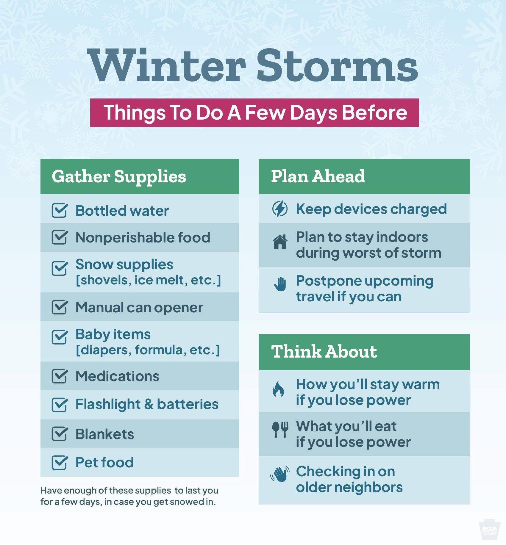
Storm Preparation Tips
Horsham Community Police Services is advising residents how to help emergency crews during the storm:
- Stay off the roads: If you don't absolutely have tobe on the roads, stay home.
- Keep fire hydrants clear: If you are physically able, keep the area in front, in back, and to the sides of the closest fire hydrant to your home clear of snow.
- Prepare for power losses: Plan for power outages and utility interruptions.
- Be patient: Realize that response times are impacted by extreme snow. Be safe and avoid hazardous activities.
The Pennsylvania Turnpike has issued a "Severe Winter Weather Alert" for its roadway, with heavy snow and dangerous conditions expected this weekend. The PA Turnpike issued these tips:
- Adjust plans accordingly
- Check antifreeze, battery, wipers, and washer fluid
- Fill gas tank, check tire tread, and pressure
- Pack warm clothes, blankets, chargers, and food and water in your vehicle
- Expect restrictions and icy roadways across the system
The National Weather Service has provided preparation ideas in the wake of the upcoming storm.
Click here to see the preparation ideas
Get more local news delivered straight to your inbox. Sign up for free Patch newsletters and alerts.