Health & Fitness
Lansdale "Then & Now" – Part III
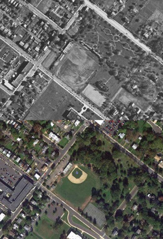
Another "Then & Now" photo combination, one more Lansdale Memorial Park picture but this time an aerial view of the park.
I love old pictures from the area, especially ones of Lansdale. But I really love “then & now” picture combinations in which a current picture is taken at the same location & angle of an old photograph and then placed side by side so you can really see the differences.
This “Then & Now” combination is another Lansdale Memorial Park picture, in keeping with the Memorial day theme, but this one is rather interesting. The “Then” photo is an aerial shot of the area from 1948. The “Now” photo is from August 2011.
Comparing the two pics the main noticeable difference is the size of the trees. You can clearly see the pathways in the park because the trees are much smaller. Most must have been fairly new plantings. Those same trees are quite large now creating a huge umbrella shading those pathways. Only other big difference in the park seems to be the parking lot behind the bleachers. There was a house and a dirt lot then.
Find out what's happening in Montgomeryville-Lansdalefor free with the latest updates from Patch.
Looking outside the park we can see a few other changes. At the top Yocum Ford razed a couple houses for expansion. At the bottom is Penndale middle school. The lower parking lot and bus driveway are there now but not then. Other than a few other added houses not a whole lot of changes for over a 60 year time span.
There is a great web site worth looking at that the “Then” picture came from. It is www.historicaerials.com It has aerial photos from several time periods from all over the country, and you can purchase a copy too. Just type in ‘Lansdale, PA’ in the search, or any other location. You can then zoom in and flipped through the different years. The Lansdale area has it for 1948, 1950, 1958, 1960, 1965, 1967, 1969, 1971, 2002 & 2008. It is really cool to see the various neighborhoods grow with new homes as you flip through the years. If you are a Disney fan type ‘Disney World’ in the search, pretty interesting.
Find out what's happening in Montgomeryville-Lansdalefor free with the latest updates from Patch.
The “Now” picture was taken from Google Maps and their satellite images. Looking at it it appears the photo is from about August 2011, you can see the new light fixtures are being installed in the ball field. I thought it was interesting that if you go on Google Maps and scan over to Railroad Ave. you can see that the Farmers Market is going on.