Crime & Safety
WEATHER ALERT: 'Major' Two-Day Snowstorm, Nor'easter To Strike Pa.
Snow will first fall early Monday, slowing the morning commute, and then turn into a nor'easter, according to the National Weather Service.

Yes, you’ve heard it before. This one could the real deal, forecasters say.
Winter Storm Juno will be a “major snowstorm” for New Jersey and eastern Pennsylvania on Monday and Tuesday, with as much as a foot of snow falling in the area.
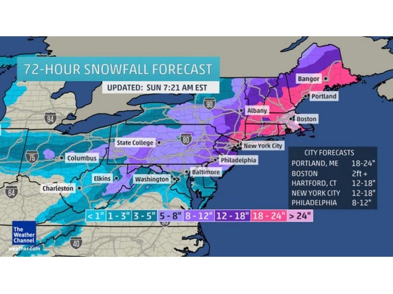
Here’s what could happen, according to The Weather Channel:
Find out what's happening in Montgomeryville-Lansdalefor free with the latest updates from Patch.
- More than 6 inches of snow could happen in the Philadelphia metro area.
- The New York City and North Jersey region is forecast to see a foot or more of heavy snow.
- Snowfall rates of more than 2 inches per hour are possible during the peak of the storm, which would be Monday night into Tuesday.
The National Weather Service has issued a Winter Storm Watch, saying ”one of the largest snow storms of the winter” may impact New Jersey and eastern Pennsylvania.
While there is still uncertainty as to the track and ferocity of a developing nor’easter late Monday, there is little doubt that snow will affect travel Monday in much of the region.
Find out what's happening in Montgomeryville-Lansdalefor free with the latest updates from Patch.
Light snow should first fall between between 2 and 6 a.m. Monday and slow the morning commute, since most untreated pavements will become slippery.
There is potential for a foot or more of snow Monday night from northern New jersey northeastward into parts of New England, according to the National Weather Service.
Most of the severe weather will impact the region from Interstate 78 northward, including the Lehigh Valley, Poconos and the northern third of New Jersey, according to the National Weather Service.
Heavy snow will blow and drift, accumulating to 6 to 16 inches in some areas of North Jersey and Pennsylvania.
Winds will move from the north at 5 to 15 mph with gusts up to 30 mph. Temperatures will mostly in the 20s for this storm. Visibility will be one-quarter to one-half-mile at times on Monday, according to the National Weather Service.
The National Weather Service has issued a Hazardous Weather Outlook for all of New Jersey and eastern Pennsylvania, saying winter storm watch is in effect from Monday afternoon through Tuesday morning.
More on Patch:
Get more local news delivered straight to your inbox. Sign up for free Patch newsletters and alerts.