Community Corner
UPDATE: Pa. Weekend Snowstorm Threat Decreases
A storm with snow is still expected to hit Eastern Pa. on the first day of spring but accumulation will be less than initially predicted.


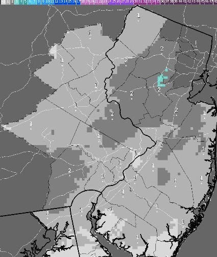
A coastal nor'easter bringing "heavy, wet" snow is still expected to hit Eastern Pennsylvania on the first day of spring, forecasters say, but accumulation will be less than initially predicted.
Forecasters on Friday were predicting four inches of snow to fall Sunday in the Philadelphia region. Accumulation estimates have decreased to one to two inches.
Forecasters with the National Weather Service acknowledged the downgraded predictions in a Tweet:
Find out what's happening in Levittownfor free with the latest updates from Patch.
Storm drums for weekend event turning into a couple college students with kazoos. Less snow in latest forecast. pic.twitter.com/T5MTF0NCqG
— Gary Szatkowski (@GarySzatkowski) March 19, 2016
The National Weather Service says the storm system could impact the region on Saturday, Sunday and early Monday.
Find out what's happening in Levittownfor free with the latest updates from Patch.
Precipitation is still expected to begin as early as Saturday night. Temperatures will be close to freezing, so the precipitation may fall as snow or as a cold rain
If we do have snow, it will likely be a "heavy wet snow," sticking to trees and power lines, according to the National Weather Service.
The NWS issued this Hazardous Weather Outlook:
A POTENTIALLY STRONG COASTAL STORM COULD BRING A MIX OF RAIN AND SNOW SUNDAY OR SUNDAY NIGHT.
Colder air will plunge into the northeastern United States and set the stage for a snowstorm in part of the region from Sunday into Monday, according to AccuWeather.
Here is the updated forecast:
Today: Partly sunny, with a high near 45. North wind 5 to 9 mph becoming light northeast in the afternoon.
Tonight: A slight chance of rain and snow before midnight. Mostly cloudy, with a low around 31. Northeast wind 5 to 9 mph. Chance of precipitation is 20%.
Sunday: Snow likely after noon. Cloudy, with a high near 37. Northeast wind 8 to 11 mph. Chance of precipitation is 70%. New snow accumulation of less than one inch possible.
Sunday Night: Snow, mainly before 2am. Low around 32. East wind 5 to 7 mph becoming light and variable. Chance of precipitation is 80%. New snow accumulation of less than one inch possible.
Monday: A slight chance of snow before noon. Mostly sunny, with a high near 49. Northwest wind 5 to 10 mph increasing to 12 to 17 mph in the afternoon. Chance of precipitation is 20%.
Monday Night: Mostly clear, with a low around 29.TuesdaySunny, with a high near 49.
Get more local news delivered straight to your inbox. Sign up for free Patch newsletters and alerts.