Weather
Winter Storm Targets New Hope-Lambertville: Latest Forecast, Cancellations, How To Prepare
A massive winter storm is expected to bring 8 to 10 inches of snow and sleet to Bucks County this weekend, forecasters said.

NEW HOPE, PA — Residents in the New Hope-Lambertville area are bracing for a winter storm on Sunday that could bring 8 to 10 inches of snow and sleet to the region.
Patch has compiled the latest forecast, storm preparation suggestions, reported closures, snow emergencies, and other information people need to know as the storm is set to pound the area with anywhere from 8 to 10 inches of snow.
Patch will provide updates as more announcements are made on closures, schools, roads and highways, businesses, and more.
Find out what's happening in New Hope-Lambertvillefor free with the latest updates from Patch.
Latest Forecast
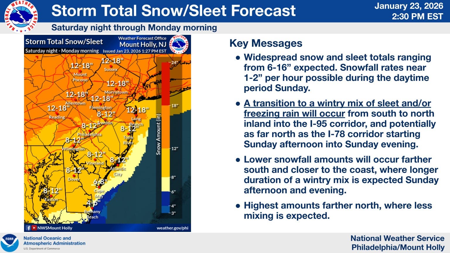
- Sleet and freezing rain chances have increased for the Interstate 95 corridor, which would lessen snow accumulation across most of Bucks County, the National Weather Service of Mount Holly, N.J., reported Friday morning.
- A Winter Storm Warning is in effect through 1 p.m. on Monday.
- Hazards: Significant snowfall accumulations are still expected, but may be closer to 8 to 10 inches due to the mixing of snow, sleet and freezing rain in the lower and central parts of the county with higher amounts in the northern end. The storm will be followed by a dangerous stretch of cold with wind chills in the single digits or below zero.
- Impacts: Heavy snow and ice accumulation will make travel dangerous or impossible. Expect widespread road closures and delays. Some power outages and tree damage is possible with ice accumulations. Dangerous cold could result in hypothermia and frostbite for those outside for long periods and may impact infrastructure due to increased heating demand.
- Timing: Dangerous cold temperatures are expected to begin Friday night and will continue throughout next week. Snow is expected Saturday night through early Monday afternoon. The mix of snow and sleet and freezing rain is likely during the day on Sunday.
Snow Emergencies
- The Mayor of New Hope has declared a Snow Emergency due to a winter storm forecast to impact the area over the weekend.The snow emergency will be in effect from Friday, January 23 at 7 a.m. and through Wednesday, January 28 at 7 p.m. During this period, residents are reminded to: Avoid unnecessary travel, comply with posted snow emergency parking restrictions, remove vehicles from designated snow emergency routes, allow public works and emergency responders to operate safely and efficiently, vehicles parked in violation of snow emergency regulations may be ticketed and/or towed, snow and ice must be removed from sidewalks and pedestrian walkways within 24 hours after the end of the storm. Residents and businessowners are asked to monitor borough communications for updates and to use caution if travel is necessary.
- Solebury Township has declared a snow emergency effective Saturday, January 24 at 7 p.m. The emergency will remain in effect until township Officials can determine the roadways are safe to travel. As a reminder, during the extent of the emergency vehicles found abandoned will be ticketed and towed at the owner's expense. Also, staying off the roadways will ensure that the Public Works Department and Emergency Services have clear passages to plow snow and respond to emergencies.
- The City of Lambertville issued the following advisory on Friday: "This weekend's predicted storm could result in anywhere between six and 16 inches of snow and up to an inch of ice, starting overnight Saturday through Monday morning. We advise all residents to take precautions to prepare for the storm. The City staff is well prepared and the Lambertville Office of Emergency Management is standing by and ready to activate. Storm updates, office closures and any important annoucements will be posted to the City Facebook page." In the case of an emergency, call 911. For non-emergency concerns, contact the police department at 609-397-3132.
Community Notices
- The Lambertville Historical Society is scheduled to hold its annual meeting on Sunday, Jan. 25 at 1 p.m. at the Phillip Pittore Justice Center, 21 South Union Street. The meeting will be followed by a presentation on the future of Washington Crossing State Park. The meeting will be streamed live via a Zoom link, which is available on the society's Facebook page.
- Due to the impending snowstorm, Phillips’ Mill will be closed on Sunday, January 25. As a result, the opening of the Youth Art Show scheduled for Sunday has been postponed. The Youth Art Exhibition will be open to the public on Saturdays and Sundays, from January 31 through February 15, from 12 to 4 pm.
Transportation Delays Possible
- Besides access to local roads and highways being limited due to the storm, SEPTA officials are warning of disruptions and possible service shutdowns on its regional rail lines.
Travel Safety
- Avoid non-essential travel once snowfall begins. Allow extra time for necessary travel and expect hazardous conditions. Ensure vehicles are fueled and cleared of all snow and ice before driving.
Home and Property Safety
- Clear sidewalks, driveways, and fire hydrants as required by ordinance. Use caution when shoveling to prevent injury. Keep heating systems, exhaust vents, and flues clear of snow and ice.
Power and Utilities
- Prepare for possible power outages. Keep flashlights, batteries, and charging devices available. Never operate grills or generators indoors.
Emergency Access and Community Awareness
- Keep driveways and access points clear for emergency vehicles. Monitor official municipal communications for updates. Check on elderly neighbors or residents with mobility challenges
Major Storm History
- The last time at least 12 inches of snow in one day in Philadelphia was on Jan. 23, 2016, when 19.6 inches of snow fell, according to the National Weather Service in Mount Holly, N.J.
Get more local news delivered straight to your inbox. Sign up for free Patch newsletters and alerts.