Weather
7 Straight Days Of Possible Thunderstorms As Heat Wave Rolls In
Prepare for some wet and hot weather ahead, forecasters say.


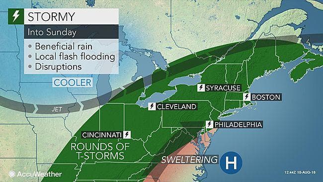
Prepare for some wet and hot weather ahead, forecasters say. A stormy weather pattern will make its way to the region starting today, and will bring with it excessive heat.
An excessive heat watch is in place Thursday through Saturday across the Philadelphia region. Temperatures will feel nearly 100 degrees with the heat index value, according to the National Weather Service.
In addition to the sweltering heat, expect lots of chances for thunderstorms. In fact, there's a chance of storms everyday for seven straight days, according to the National Weather Service forecast.
Find out what's happening in Newtownfor free with the latest updates from Patch.
"A very humid air mass in place across the Northeast and Ohio Valley will lead to the opportunity for drenching showers and thunderstorms to develop across the region through the weekend," AccuWeather Senior Meteorologist Dan Pydynowski said.
Rainfall amounts of 1 to 2 inches per hour are possible during some of the storms, according to AccuWeather. "Some communities could end up with between 3-5 inches of rain by the end of the weekend," forecasters there predict.
Find out what's happening in Newtownfor free with the latest updates from Patch.
There is currently a 50 percent chance of thunderstorms on Thursday, Sunday and Monday. Today, Friday and Saturday, there is a 40 percent chance.
Here is the forecast:
Today: Isolated showers, then scattered showers and thunderstorms after noon. Mostly cloudy, with a high near 88. Southwest wind around 9 mph. Chance of precipitation is 30%. New rainfall amounts of less than a tenth of an inch, except higher amounts possible in thunderstorms.
Tonight: A chance of showers and thunderstorms, mainly before 1am. Mostly cloudy, with a low around 75. South wind 3 to 6 mph. Chance of precipitation is 40%. New rainfall amounts of less than a tenth of an inch, except higher amounts possible in thunderstorms.
Thursday: A chance of showers and thunderstorms. Mostly cloudy, with a high near 90. Southwest wind around 8 mph. Chance of precipitation is 50%. New rainfall amounts between a quarter and half of an inch possible.
Thursday Night: A chance of showers and thunderstorms, mainly before midnight. Mostly cloudy, with a low around 74. Southwest wind around 7 mph. Chance of precipitation is 30%. New rainfall amounts between a tenth and quarter of an inch, except higher amounts possible in thunderstorms.
Friday: A chance of showers and thunderstorms. Partly sunny, with a high near 92. Southwest wind 7 to 11 mph. Chance of precipitation is 40%. New rainfall amounts between a tenth and quarter of an inch, except higher amounts possible in thunderstorms.
Friday Night: A slight chance of showers and thunderstorms. Mostly cloudy, with a low around 76. Chance of precipitation is 20%.
Saturday: A chance of showers and thunderstorms. Partly sunny, with a high near 93. Chance of precipitation is 40%.
Saturday Night: A chance of showers and thunderstorms. Mostly cloudy, with a low around 76. Chance of precipitation is 30%.
Sunday: A chance of showers and thunderstorms. Mostly cloudy, with a high near 90. Chance of precipitation is 50%.
Sunday Night: A chance of showers and thunderstorms. Mostly cloudy, with a low around 74. Chance of precipitation is 40%.
Monday: A chance of showers and thunderstorms. Mostly cloudy, with a high near 87. Chance of precipitation is 50%.
Monday Night: A chance of showers and thunderstorms. Mostly cloudy, with a low around 70. Chance of precipitation is 30%.
Tuesday: A chance of showers and thunderstorms. Partly sunny, with a high near 83. Chance of precipitation is 30%.
Get more local news delivered straight to your inbox. Sign up for free Patch newsletters and alerts.