Weather
Forecasters Eyeing Possible Weekend Snow For PA
Forecasters are eyeing the possibility of some weekend snow across the Philadelphia region. Here's what you can expect, and when:


Forecasters are eyeing the possibility of some weekend snow across the Philadelphia region.
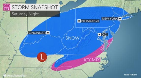
A storm system heading eastward is expected to drop as much as a foot of snow on parts of North Carolina, Virginia and West Virginia. While the system is not expected to impact the Philadelphia region to that extent, we can expect the possibility of some accumulation on Saturday night into Sunday, the National Weather Service says.
"Only if the storm strengthens dramatically along the coast and turns northward would heavy snow spread into areas from southeastern Pennsylvania and central New Jersey to Massachusetts," according to information from AccuWeather.
Find out what's happening in Newtownfor free with the latest updates from Patch.
"The concern for a storm from the Great Lakes to merge with the storm on the Atlantic coast and become much stronger and track farther north appears less likely at this time," said AccuWeather Senior Meteorologist Brett Anderson.
As of now, accumulation is expected to be light in our area. Current predictions from The Weather Channel call for about an inch. The NWS, which issued a Hazardous Weather Outlook ahead of the possibility, has not yet released its accumulation estimates for the Philadelphia region.
Find out what's happening in Newtownfor free with the latest updates from Patch.
Daytime temperatures are expected to remain in the upper 40s Wednesday, dipping down to the 30s as the week progresses. Nighttime lows could hit the teens on Friday, and will likely be in the mid-20s on Saturday.
By next week, daytime temperatures are expected to warm to the 40s.
Here is the current local forecast:
Today: Isolated snow showers after 1pm. Partly sunny, with a high near 46. Breezy, with a northwest wind 14 to 21 mph, with gusts as high as 34 mph. Chance of precipitation is 20%.
Tonight: Mostly cloudy, with a low around 27. West wind 16 to 18 mph, with gusts as high as 30 mph.
Thursday: Partly sunny, with a high near 37. Breezy, with a northwest wind 13 to 21 mph, with gusts as high as 33 mph.
Thursday Night: Mostly clear, with a low around 21. Northwest wind 11 to 14 mph.
Friday: Sunny, with a high near 32. Northwest wind 9 to 11 mph.
Friday Night: Mostly clear, with a low around 19.
Saturday: Partly sunny, with a high near 32.
Saturday Night: A chance of snow. Cloudy, with a low around 24. Chance of precipitation is 40%.
Sunday: A chance of snow. Mostly cloudy, with a high near 31. Chance of precipitation is 40%.
Sunday Night: Mostly cloudy, with a low around 20.
Monday: Mostly sunny, with a high near 34.
Monday Night: Partly cloudy, with a low around 23.
Tuesday: Sunny, with a high near 40.
Main image via Shutterstock
Get more local news delivered straight to your inbox. Sign up for free Patch newsletters and alerts.