Community Corner
Rain or Snow? Forecasters Release Details On Upcoming Storm
Forecasters have released details on a storm that could hit Pennsylvania beginning Wednesday and lasting through Thursday.

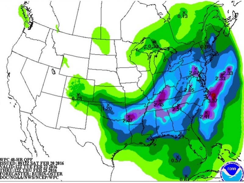
A winter storm anticipated to hit the region mid-week looks like it will end up being rain, with a chance of snow in the Lehigh Valley and the Poconos, according to the latest information released by the National Weather Service. Forecasters have been tracking the storm since last week, saying there was a chance it could bring snow.
The National Weather Service has issued a Hazardous Weather Outlook, saying a “strong storm” is expected Wednesday into Thursday. The storm will bring heavy rain to the Philadelphia region, posing a flooding risk, the NWS said.
“Chances for wintry precipitation have decreased for locations further to the south,” the NWS said in its latest briefing.
Find out what's happening in Newtownfor free with the latest updates from Patch.
Some wintry precipitation is still possible, however, but is more likely in the Poconos, Lehigh Valley and some parts of Northern New Jersey, according to the NWS.
Precipitation is expected to range from 1 to locally 2 inches across the region with most of that falling as rain, the NWS said. “This may result in urban and poor drainage flooding along with minor river flooding in the mid-week period,” the briefing said.
Find out what's happening in Newtownfor free with the latest updates from Patch.
While the likelihood of “major impacts” from the storm have decreased since earlier predictions, residents should continue to monitor the forecast, the NWS said.
There could be travel impacts, Accuweather says. The storm “has the potential to be disruptive to travel because it could cover a large area with a wide variety of weather,” AccuWeather Chief Meteorologist Elliot Abrams said.
However, the details “are still uncertain with the exact impacts from this system,” according to the NWS briefing.
Before that storm arrives, there is the potential for another system in the region Sunday night and early Monday morning.
That storm has the potential for “a slight chance” of snow in the higher terrain of the Southern Poconos and Northwest New Jersey, according to the NWS.
Here is the forecast:
Tonight: A chance of rain, mainly before 1am. Mostly cloudy, with a low around 36. North wind 6 to 9 mph. Chance of precipitation is 50%. New precipitation amounts between a tenth and quarter of an inch possible.
Monday: Mostly sunny, with a high near 49. North wind 6 to 9 mph.Monday NightPartly cloudy, with a low around 28. Northeast wind around 5 mph.
Tuesday: A chance of rain after noon. Mostly cloudy, with a high near 46. East wind 6 to 10 mph. Chance of precipitation is 30%. New precipitation amounts of less than a tenth of an inch possible.
Tuesday Night: A chance of rain. Cloudy, with a low around 35. Chance of precipitation is 40%. New precipitation amounts of less than a tenth of an inch possible.
Wednesday: Rain likely. Cloudy, with a high near 46. Chance of precipitation is 60%.
Wednesday Night: Rain likely. Cloudy, with a low around 42. Chance of precipitation is 70%.
Thursday: A chance of rain. Mostly cloudy, with a high near 53. Chance of precipitation is 40%.
Get more local news delivered straight to your inbox. Sign up for free Patch newsletters and alerts.