Weather
Hazardous Weather Outlook Issued As Weekend Storms Approach
Forecasters say thunderstorms with high winds and hail are again possible in Pennsylvania this weekend.

Looks like the summer fun might be put on hold a bit this weekend.
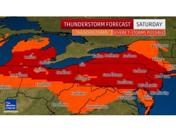
More severe thunderstorms with hail and strong winds are possible Saturday in Pennsylvania, mainly in the Eastern and Central parts of the state.
The National Weather Service has issued a "Hazardous Weather Outlook" in 10 counties, saying the severe thunderstorms will possibly hit Saturday afternoon in the evening and could come with damaging wind gusts and hail.
Find out what's happening in Newtownfor free with the latest updates from Patch.
Counties included in the Hazardous Weather Outlook include: Bucks, Chester, Delaware, Montgomery, Philadelphia, Carbon, Monroe, Berks, Lehigh and Northampton.
"Those with outdoor plans or events should be aware of the risk," the Hazardous Weather Outlook says.
Find out what's happening in Newtownfor free with the latest updates from Patch.
Locally "violent" thunderstorms could come with winds capable of downing trees and power lines, according to an AccuWeather release. The probability of tornadoes appears to be low, although isolated tornadoes can occur in these situations, according to The Weather Channel.
Those with plans to swim at a local pool or attend an outdoor festival should keep an eye to the sky and be prepared to seek shelter at the first clap of thunder, AccuWeather recommends.
Severe thunderstorms will become more possible from the Upper Midwest into the Northeast as building heat and humidity interact with an active jet stream, according to The Weather Channel.
A hail storm rocked the Philadelphia region Wednesday, causing widespread power outages.
Now for the good news? Sunday and early next week looks magical, weather-wise.
Here is the forecast:
Today: Sunny, with a high near 78. Northwest wind 9 to 11 mph.
Tonight: Mostly clear, with a low around 55. Northwest wind around 5 mph becoming calm in the evening.
Saturday: Scattered showers and thunderstorms after noon. Some of the storms could produce gusty winds. Partly sunny, with a high near 85. Light and variable wind becoming southwest 8 to 13 mph in the morning. Chance of precipitation is 40%. New rainfall amounts of less than a tenth of an inch, except higher amounts possible in thunderstorms.
Saturday Night: Scattered showers and thunderstorms, mainly before 2am. Some of the storms could produce gusty winds. Mostly cloudy, with a low around 67. Southwest wind 8 to 10 mph. Chance of precipitation is 40%. New rainfall amounts between a tenth and quarter of an inch, except higher amounts possible in thunderstorms.
Sunday: Mostly sunny, with a high near 84. Breezy, with a northwest wind 14 to 21 mph, with gusts as high as 31 mph.
Sunday Night: Partly cloudy, with a low around 57.
Monday: Mostly sunny, with a high near 81.
Monday Night: Partly cloudy, with a low around 60.
Tuesday: Mostly sunny, with a high near 80.
Tuesday Night: Mostly cloudy, with a low around 61.
Wednesday: Partly sunny, with a high near 82.
Get more local news delivered straight to your inbox. Sign up for free Patch newsletters and alerts.