Weather
Hurricane Matthew Track Shifts, Hazardous Weather Outlook Issued In Pennsylvania
The exact path of the Category 4 storm is still uncertain.

As Hurricane Matthew approached Haiti early Tuesday, its projected path for later in the week shifted more to the west with a large swath of Florida — and possibly South Carolina, North Carolina, New Jersey and even parts of Pennsylvania— now in its sights.
The National Weather Service has issued a Hazardous Weather Outlook for Eastern Pennsylvania, including the following counties: Philadelphia, Chester, Montgomery, Bucks, Delaware, Lehigh, Carbon, Monroe, Berks and Northampton.
Get Patch breaking news alerts sent right to your phone with our new app. Download here.
Find out what's happening in Newtownfor free with the latest updates from Patch.
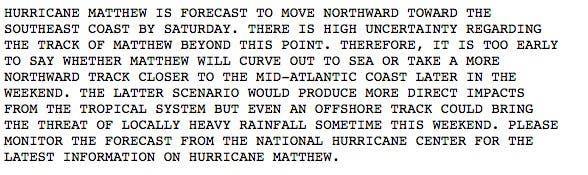
According to the National Weather Service's Hazardous Weather Outlook, Hurricane Matthew, which is currently churning with 145 mph maximum sustained winds, is forecast to move northward toward the southeast coast this weekend.
The track of the storm initially appeared to have the storm shifting out to the sea. But over the last 24 hours, those same forecasters have said that the storm could likely stick close to the East Coast. If the Philadelphia region were to be impacted, it likely wouldn't come until Saturday at the earliest, either packing gusty winds, heavy rainfall or both.
Find out what's happening in Newtownfor free with the latest updates from Patch.
Don't panic just yet: There is "high uncertainty" regarding the storm track at this time. Forecasters are presently just advising residents to be aware of the situation by monitoring the latest information.
"It is too early to say whether Matthew will curve out to sea or take a more northward track closer to the mid-Atlantic later in the weekend," the NWS says. If the track is close to Philadelphia, there could be direct impacts, but even an offshore track could bring heavy rainfall, NWS forecasters warn.
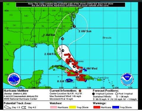
The southern tip of New Jersey, or the Cape May region, now finds itself in the National Hurricane Center's so-called "cone of uncertainty" as the Category 4 storm, packing 140 mph-plus winds, is anticipated to arrive near the Sunshine State Thursday evening.
As forecasters track Matthew’s trek through the Caribbean, they’re keeping a close watch on another system in the Atlantic Ocean. That disturbance may have an impact on the East Coast in the future as it makes its way west-northwest from the Leeward Islands.
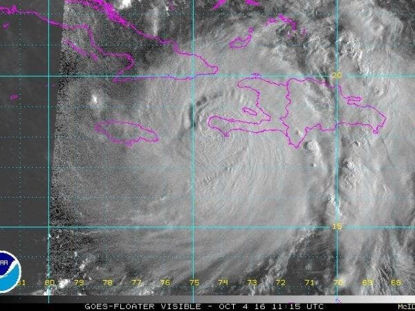
Hurricane Matthew made landfall south of Tiburon, Haiti, according to The Weather Channel's Tuesday morning update. The storm was moving north at 7 mph, packing 145 mph winds at the time.
Forecasters offered models that showed Matthew's possible paths, which have it either straddling the coast in South Carolina and North Carolina and possibly impacting the Philadelphia region, or heading out to sea.
Matthew 00Z model set pic.twitter.com/DPyA5gyiJC
— James Spann (@spann) October 4, 2016
The National Hurricane Center also offered its own advisory:
Here are the key messages from NHC regarding Category 4 #hurricane #Matthew at 5am EDT Tuesday https://t.co/T8bABTTyjI @NHCDirector @NOAA pic.twitter.com/XWfv1X2ppe
— NHC Atlantic Ops (@NHC_Atlantic) October 4, 2016
On its current projected path, Matthew is expected to impact Cuba Tuesday before moving on to the Bahamas Wednesday. A shift in direction to the north-northwest is also expected on Wednesday. Forecasters anticipate the storm will be offshore of Florida's east coast by Thursday evening with possible landfall in the southern part of the state.
Florida Gov. Rick Scott has declared a state of emergency in advance of the storm's arrival. The declaration covers every county in the Sunshine State.
Hurricane Matthew has killed a man in Colombia, a 16-year old in St. Vincent and the Grenadines and two men in Haiti, according to the Chicago Tribune.
By Tom Davis and Kara Seymour
Photo courtesy of NOAA
Get more local news delivered straight to your inbox. Sign up for free Patch newsletters and alerts.