Weather
Season's First Frost On The Way To Eastern Pennsylvania
Overnight temperatures will dip into the 30s tonight, so cover those outdoor plants if you want to keep them alive a little longer.


Chilly conditions will continue today, with the season's first frost coming overnight Thursday into Friday, the National Weather Service predicts. A Hazardous Weather Outlook has been issued ahead of the frost. Temperatures in the Philadelphia region will dip to the mid 30s overnight.
Residents should cover up any plants they'd like to keep alive before the sun sets so as to retain heat, the NWS advises.
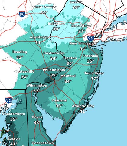
Here's a look at the predicted morning lows for Friday:
Find out what's happening in Newtownfor free with the latest updates from Patch.
Some warmer daytime temperatures will return Friday and Saturday, when highs will be in the 60s across the region. However, it won't last long.
“After a brief moderation in temperatures on Friday, a reinforcing shot of colder air will be coming into the Northeast this weekend,” said AccuWeather Meteorologist Ryan Adamson.
Find out what's happening in Newtownfor free with the latest updates from Patch.
And this next cold front "means business,” the AccuWeather news release said. The chill will go through the Upper Midwest and Great Lakes on Saturday, and then enter the Northeast from late Saturday to Saturday night.
The hight temperature Sunday will only reach the upper 40s. Also some gusty winds are possible, AccuWeather said.
And while the skies should be clear for the peak of the Orionid meteor shower on Sunday night, be sure to dress warmly if you're venturing outside to watch.
Here is the forecast:
Today: Sunny, with a high near 51. Northwest wind around 13 mph, with gusts as high as 23 mph.
Tonight: Patchy frost after 2am. Otherwise, clear, with a low around 35. West wind around 6 mph.
Friday: Patchy frost before 8am. Otherwise, sunny, with a high near 59. Southwest wind around 6 mph.
Friday Night: Showers likely, mainly after 2am. Mostly cloudy, with a low around 48. Southwest wind 3 to 6 mph. Chance of precipitation is 60%. New precipitation amounts of less than a tenth of an inch possible.
Saturday: Showers likely, mainly before 8am. Mostly cloudy, with a high near 62. West wind 6 to 9 mph. Chance of precipitation is 60%. New precipitation amounts of less than a tenth of an inch possible.
Saturday Night: Partly cloudy, with a low around 41.
Sunday: Mostly sunny, with a high near 48.
Sunday Night: Mostly clear, with a low around 33.
Monday: Sunny, with a high near 52.
Get more local news delivered straight to your inbox. Sign up for free Patch newsletters and alerts.


