Weather
Severe Storms Heading To Eastern Pennsylvania Wednesday: NWS
Strong thunderstorms packing 60-mph wind gusts are expected to hit Eastern Pennsylvania on Wednesday.


EASTERN PENNSYLVANIA — Strong thunderstorms packing 60-mph wind gusts are expected to hit Eastern Pennsylvania on Wednesday, brining drenching rain that could cause nightmares for commuters.
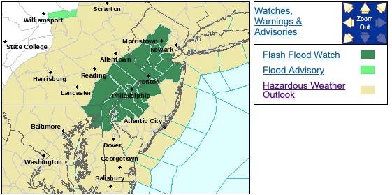
The National Weather Service has issued a hazardous weather outlook and a flash flood watch ahead of thunderstorms predicted Wednesday afternoon and evening. Some of the storms may be severe, with damaging winds the primary threat, the NWS said.
The showers and thunderstorms are forecast to bring periods of heavy rain to the region after 3 p.m., the NWS said. Rainfall totals of 1 to 2 inches are expected for some areas, with local amounts of up to 3 to 4 inches possible.
Find out what's happening in Newtownfor free with the latest updates from Patch.
.png)
The rain could fall in a short period of time which could lead to areas of flash flooding. Wind gusts as strong as 60-mph or more are possible, forecasters warn.
As heat and humidity hold on in the eastern United States, a slow-moving swath of drenching showers and thunderstorms will advance from the Appalachians and eventually stall, according to AccuWeather.
Find out what's happening in Newtownfor free with the latest updates from Patch.
As the storms approach heavily populated areas, travel disruptions will increase with the potential for some roads to be blocked by rapidly rising water, AccuWeather warned.
.png)
"The afternoon commute could prove to be difficult and slow in the major cities, so motorists should be prepared for delays and reduce speeds in heavy downpours to lessen the risk for hydroplaning," AccuWeather Meteorologist Kyle Elliott said in a news release.
.jpeg)
Here is the forecast
Today: Showers and thunderstorms likely, mainly after 3pm. Some storms could be severe, with damaging winds and heavy rain. Mostly cloudy, with a high near 88. Calm wind becoming west 5 to 7 mph in the afternoon. Chance of precipitation is 60%. New rainfall amounts between a half and three quarters of an inch possible.
Tonight: Showers and thunderstorms likely, mainly before 9pm. Some storms could be severe, with damaging winds and heavy rain. Patchy fog after 1am. Otherwise, mostly cloudy, with a low around 67. Calm wind. Chance of precipitation is 60%. New rainfall amounts between a quarter and half of an inch possible.
Thursday: Mostly sunny, with a high near 87. North wind 3 to 5 mph.
Thursday Night: Partly cloudy, with a low around 66. Calm wind.
Friday: A chance of showers and thunderstorms, mainly after 2pm. Mostly sunny, with a high near 86. Light northeast wind. Chance of precipitation is 30%. New rainfall amounts of less than a tenth of an inch, except higher amounts possible in thunderstorms.
Friday Night: A chance of showers and thunderstorms. Mostly cloudy, with a low around 67. Chance of precipitation is 30%. New rainfall amounts of less than a tenth of an inch, except higher amounts possible in thunderstorms.
Saturday: A chance of showers, with thunderstorms also possible after 8am. Mostly cloudy, with a high near 86. Chance of precipitation is 40%.
Saturday Night: A chance of showers and thunderstorms before 2am. Partly cloudy, with a low around 67. Chance of precipitation is 30%.
Get more local news delivered straight to your inbox. Sign up for free Patch newsletters and alerts.