Weather
Severe Storms With Penny-Sized Hail Moving Through Region: NWS
Storms with "torrential" rainfall, high winds, and even penny-sized hail are in the forecast for the Philadelphia area Thursday.

Storms with "torrential" rainfall, high winds, and even hail are in the forecast for the Philadelphia area Thursday. The National Weather Service has issued both a Flash Flood Watch and a Hazardous Weather Outlook, saying the storms could produce heavy rainfall and gusty winds.
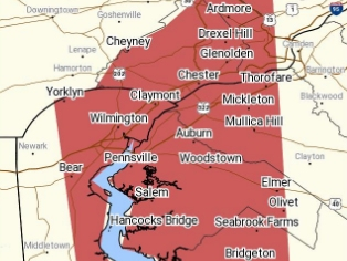
A Severe Thunderstorm Warning is also in place through 2:45 p.m. in parts of Delaware and Montgomery counties. Forecasters are warning of 60 mph wind gusts and penny-sized hail due to a system currently moving through that area.
Severe Thunderstorm Warning including Wilmington DE, Chester PA, Drexel Hill PA until 2:45 PM EDT pic.twitter.com/Rgt6S6aGf3
— NWS Mount Holly (@NWS_MountHolly) July 11, 2019
Thunderstorms are in the forecast throughout the night, the NWS predicts. The Flash Flood Watch goes from 2 p.m. Thursday to 1 a.m. Friday.
Find out what's happening in Newtownfor free with the latest updates from Patch.
"Showers and thunderstorms this afternoon and tonight will be capable of producing torrential rainfall, with local amounts of 1 to 3 inches with locally higher amounts potentially occurring in a short period of time. This could lead to localized flash flooding," the NWS warned.
Rapid rises on small creeks and streams are possible.
Find out what's happening in Newtownfor free with the latest updates from Patch.
Residents in areas that are prone to flooding should closely monitor the forecast.
The Weather Channel is predicting the heaviest thunderstorms for the region will come in the late afternoon and early evening.
Conditions should dry out by Friday, when partly sunny skies are predicted. The weekend also looks to be pleasant, with sunshine and temperatures in the 80s.
Get more local news delivered straight to your inbox. Sign up for free Patch newsletters and alerts.


