Weather
NWS Updates Snowfall Predictions For Sunday Storm
The NWS has updated its snowfall predictions for Sunday's storm, saying up to 7 inches is now possible in some parts of the Philly region.


The National Weather Service has increased its snowfall predictions for a "significant" winter storm that's predicted Sunday into Monday across the Philadelphia region. How much snow actually falls remains highly dependent on the temperature.
A Winter Storm Watch is in place starting at 1 p.m. Sunday and going through 7 a.m. Monday, when heavy snow and mixed precipitation is possible in the Philadelphia region.
However, the specific impacts of the storm remain uncertain even the day before. That's because temperatures will be hovering just around freezing and at this point forecasters are unable to predict if it will remain cold enough for snow.
Find out what's happening in Newtownfor free with the latest updates from Patch.
If so, the storm could materialize with snowfall accumulation of up to seven inches in some areas. If temperatures stay above freezing, expect precipitation to come as rain, freezing rain, or sleet.
"Colder temperatures and heavier precipitation rates may result in higher snow amounts shifting more into the I-95 to NJ Turnpike corridor," the NWS said.
Find out what's happening in Newtownfor free with the latest updates from Patch.
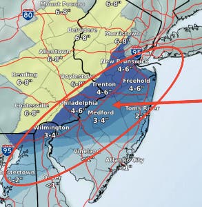
As of the latest update provided Saturday evening by the NWS, forecasters are predicting seven inches in the northern and western suburbs of Philadelphia. Philadelphia and its immediate surrounding areas could see four to five inches, the NWS said.
Here is a map issued Saturday evening by the NWS. The circled area shows where forecasters are currently uncertain if precipitation will fall predominately as snow or rain.
Portions of the region that should brace for the biggest impacts of the storm include the northern and western suburbs, which could see as much as six inches. Philadelphia and its immediate suburbs can expect about two or three inches, the NWS predicts as of Saturday morning.
The Weather Channel is predicting the storm will arrive to the Philadelphia region in the early evening. It could start as rain and may blend with snow or turn to all snow. Precipitation is predicted to stop around 3 a.m., the Weather Channel says.
Current temperature predictions range from 32 in Philadelphia and its immediate suburbs, to 30 in suburbs to the west and north.
Check back for updates as additional information becomes available.
Get more local news delivered straight to your inbox. Sign up for free Patch newsletters and alerts.


