Weather
Snow Estimates For 2 Storms, But Ice Likely Bigger Threat In PA
Snow will fall but ice might be the bigger threat. Prepare for possible prolonged and widespread power outages, forecasters warn.


Prepare for some not-so-nice weather through the weekend, including the potential for power loss and travel complications.
Forecasters are tracking two storms: one which will likely leave behind some snow and cause a disruption to the Friday morning commute, and another that will make the weekend a snowy, icy mess. The weekend storm also threatens widespread and prolonged power outages, according to forecasters.
The string of threatening winter weather starts Thursday night with snow showers expected to begin around 10 p.m. in the Philadelphia region. Snowfall will pick up and fall through the early morning hours, stopping around 7 a.m., according to The Weather Channel.
Find out what's happening in Newtownfor free with the latest updates from Patch.
One to two inches of snow is predicted.
Tonight: Light snow mainly along and outside the I-95 corridor could make for slippery travel Friday AM. The forecast snowfall is below. A more significant storm will impact us this weekend. More details on that system will be available this evening. #NJwx #PAwx #DEwx #MDwx pic.twitter.com/L2OIvTOqaF
— NWS Mount Holly (@NWS_MountHolly) January 17, 2019
A more significant storm is on the way this weekend, and could bring two days of snow, rain, and ice. There is a risk of widespread and prolonged power outages due to the expected winds, forecasters warn.
Find out what's happening in Newtownfor free with the latest updates from Patch.
Accuweather is calling the storm potentially "immobilizing" and there are serious risks associated with probable power outages just as single-digit temperatures roll in.
The weekend system will arrive with a chance of snow showers Saturday afternoon. Precipitation is expected to mix with rain as the day goes on.
"While the heaviest total accumulation of snow from the storm will fall north of the Interstate 95 cities from Washington, D.C., to Baltimore, Philadelphia, New York City and Boston, enough wintry precipitation can occur in the heart of the cities or just northwest to cause slippery conditions," according to AccuWeather.
Snowfall estimates for our area for the weekend storm are not clear at this point. The National Weather Service, in a Hazardous Weather Outlook, says "significant" snow accumulation is probable across the southern Poconos and northern New Jersey.
The biggest threat to our region will likely be ice, forecasters say, as the winter weather continues with a mix of rain and snow on Sunday that will change to all snow in the late afternoon and evening.
"A flash freeze will occur on wet surfaces later Sunday afternoon and night as arctic air rapidly overspreads our area," the NWS said.
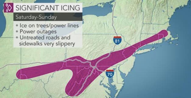
According to forecaster Gary Szatkowski, the potential for more than a half-inch of ice coupled with blustery winds could result in power outages that last days, or even weeks in some areas.
Regarding the weekend winter storm event, I see a lot of people discussing snow amounts (as usual) and then also mentioning (sometimes) the icing potential for over 0.5" icing. Given the expected winds, we are looking at potential for Level 3 or 4 on this icing index. pic.twitter.com/xh3BKgCcVi
— Gary Szatkowski (@GarySzatkowski) January 17, 2019
The weekend storm will be followed by dangerously cold temperatures. The overnight lows Sunday and Monday in the Philadelphia region are expected to be in the single digits. Temperatures could go down to 6 degrees in Philadelphia, and even lower — down to 2 — in areas north, including around Doylestown and Lansdale.
More specifics on the weekend storm are expected later Thursday in a briefing package from the National Weather Service.
Check back for updates.
IMAGE: NWS snowfall prediction map for snow Thursday into Friday
Get more local news delivered straight to your inbox. Sign up for free Patch newsletters and alerts.


