Weather
Snowfall Estimates For Next Round Of Winter Weather In Eastern PA
The Winter Weather Advisory has been extended through Tuesday at noon. Here's how much snow could fall and when.

A Winter Weather Advisory has been extended through Tuesday as another round of winter weather is expected to pass through the Philadelphia region.
Snow overnight Sunday into Monday morning left a dusting of snow on the roads, and caused some school delays. Now, forecasters are looking ahead to the next round of winter weather, which could leave behind accumulating snow everywhere from Philadelphia to the Poconos.
How much snow?
Find out what's happening in Newtownfor free with the latest updates from Patch.
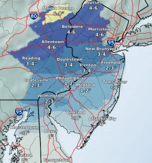
Snowfall estimates for the next storm just released Monday morning indicate that accumulation could vary widely throughout Eastern Pennsylvania. Philadelphia could see just one or two inches. Further north in the Poconos, as much as eight inches could fall.
The Philadelphia suburbs to the west and north will likely experience between two and four inches. Additionally, residents should be aware that power outages are possible due to ice.
Find out what's happening in Newtownfor free with the latest updates from Patch.
There is some uncertainty in the snowfall total predictions, the NWS said in a Monday briefing.
"The timing of transitions between snow, ice, and rain will dictate snow totals. Timing differences in transitions of only two to three hours could nearly double or halve these totals," the NWS warned.
Here is the latest accumulation map:
Timing
According to the National Weather Service, the next round of snow will move in overnight, sometimes after 1 a.m. Through late morning, expect a mix of snow, freezing rain, and sleet.
Freezing rain and sleet could linger through the afternoon. Precipitation will turn to all rain later Tuesday, with a high in the low 40s expected.
By Wednesday, expect the rain to move out, making way for partly sunny skies and a high in the low 40s.
Thursday will be mostly sunny, with a high approaching the upper 40s, the NWS said.
Image via Shutterstock
Get more local news delivered straight to your inbox. Sign up for free Patch newsletters and alerts.