Weather
Snow Squalls Threaten PA Highways, Could Hit Philly Area Friday
Conditions are ripe for potentially lethal snow squalls on the state's highways, officials say.


PENNSYLVANIA — Conditions are ripe for potentially lethal snow squalls on the state’s highways, officials say.
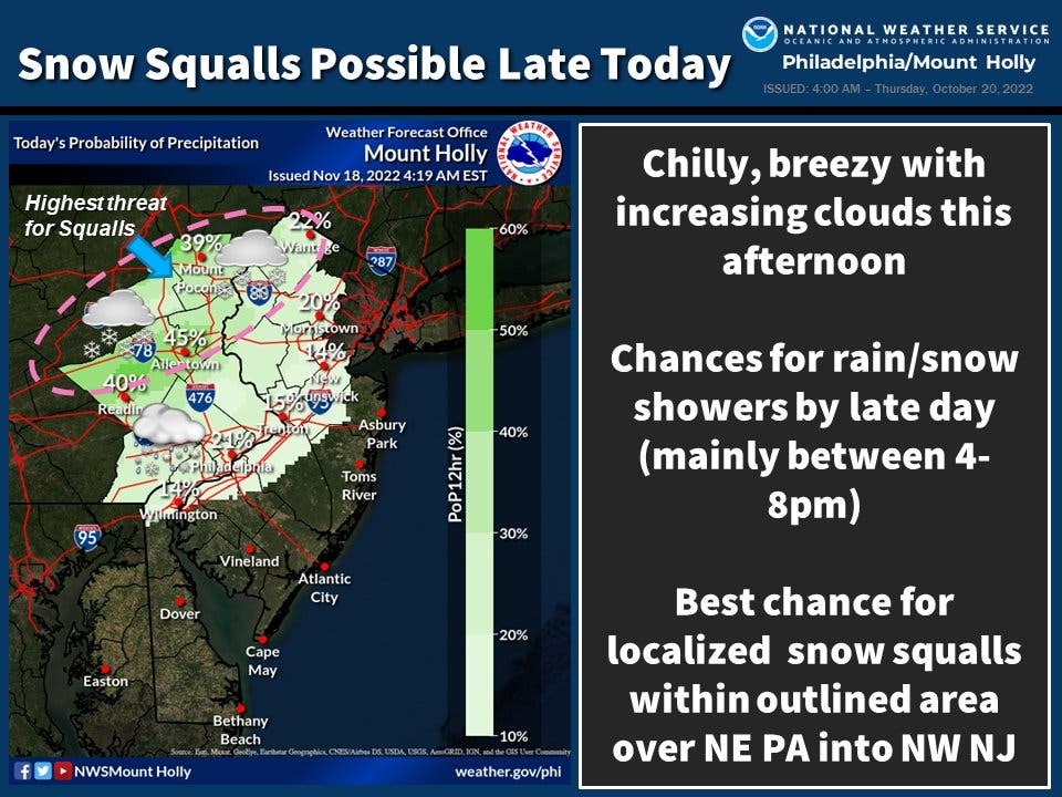
There’s a chance of rain turning to snow Friday night in the greater Philadelphia area, the National Weather Service says. Accumulation would be minimal in most areas, though more could fall in the case of sudden squalls, which are possible throughout the region.
The most likely time for snow to hit the region is between 4 p.m. and 8 p.m., according to forecasters. While some parts of Berks County and the Poconos saw snowfall earlier in the week, the storm would mark the first snowfall of the season for Philadelphia and its suburbs.
Find out what's happening in Norristownfor free with the latest updates from Patch.
Precipitation chances vary throughout the area, with the city itself seeing a 20 percent chance, and some of the outlying suburbs in the five-county region seeing a higher likelihood, forecasters said.
Regardless, all of Pennsylvania will experience "abnormally cold" temperatures, according to AccuWeather meteorologists, with temperatures plummeting to the 20s with a wind chill much lower than that.
Find out what's happening in Norristownfor free with the latest updates from Patch.
Squalls can emerge without warning. Forecasters said "narrow and steadier bands of snow" blowing off the Great Lakes could spark them.
"In areas hit by consistent snow squalls, it's possible that over a foot of snow will pile up by the end of the day Friday," AccuWeather said. "One of these areas is Pennsylvania."
The Pennsylvania Department of Transportation has declared this week Snow Squall Awareness Week, and has issued warnings to residents across the state about the danger.
“One of the things that makes snow squalls so dangerous is their tendency to produce icy roadways, or what we call a flash freeze,” National Weather Service meteorologist John Banghoff said. “Because they come on so suddenly, snow squalls can catch drivers off guard and lead to major transportation incidents, including deadly multi-vehicle accidents.”
Last year, six people were killed on I-81 in a massive pileup during a squall that officials said was one of the worst roadway tragedies in state history.
PennDOT has also launched variable speed limit signs, which call for reduced speeds when roadway conditions change quickly, at 63 locations around the state:
- 21 locations along I-80 in Clearfield (mile marker (MM) 100-133) and Clinton (MM 182-193) counties
- Six locations on I-80 in Clarion and Jefferson counties on the approaches to Emlenton Bridge (MM 42-45), North Fork Bridge (MM 78-81), and Kyle Lake Bridge (MM 92-95)
- 36 locations along I-81 from I-78 to I-80 in Lebanon (five locations), Luzerne (seven locations), and Schuylkill (24 locations) counties
Here’s the forecast for the Philadelphia area, according to the National Weather Service:
Friday
Mostly sunny, with a high near 45. West wind 5 to 15 mph.
Friday night
A slight chance of rain and snow showers, mainly between 9pm and 10pm. Mostly cloudy during the early evening, then gradual clearing, with a low around 27. West wind around 5 mph. Chance of precipitation is 20%.
Saturday
Sunny, with a high near 41. West wind 5 to 10 mph, with gusts as high as 20 mph.
Saturday night
Mostly clear, with a low around 27. Calm wind becoming west around 5 mph after midnight.
Sunday
Sunny, with a high near 36. West wind 10 to 15 mph, with gusts as high as 30 mph.
Sunday night
Clear, with a low around 24.
Get more local news delivered straight to your inbox. Sign up for free Patch newsletters and alerts.


