Weather
Major Storm Could Drop Sleet, Snow On Eastern PA This Week: Forecast
As blizzards sweep over the plains, forecasters say the east coast should brace for what could be a significant winter storm event.


See new update: Chance Of Snow In Mid-Week Storm Increases For PA
EASTERN PA — A major winter storm is moving across the country and could impact the greater Philadelphia area later this week, though forecasters are still uncertain on its timing and intensity.
The massive front is moving across the breadth of the country, likely delivering blizzards in parts of the plains and midwest and heavy rains in the south, according to AccuWeather.
Find out what's happening in Norristownfor free with the latest updates from Patch.
The storm will reach Pennsylvania by some point on Thursday, but it's still not clear exactly when. The National Weather Service's Mt. Holly, New Jersey station said Monday morning that "confidence is increasing" that the storm's biggest impacts will be Thursday into Friday.
"A potent area of low pressure is set to form over Colorado and Kansas Monday,"AccuWeather Meteorologist Thomas Geiger said. "This will pull moist air northward from the Gulf of Mexico, combining it with bitterly cold air from the polar regions in Canada."
Find out what's happening in Norristownfor free with the latest updates from Patch.
Right now, heavy rain, strong winds, and potential sleet and snow are in the outlook for much of the mid-Atlantic. Total precipitation levels remain unclear. The National Weather Service did say that 6 inches of snow was unlikely for eastern Pennsylvania and New Jersey.
The type of precipitation that hits, forecasters said, is dependent on exactly how the storm tracks in the coming days. That means that much more will likely be known come Tuesday and Wednesday about what local residents can expect. 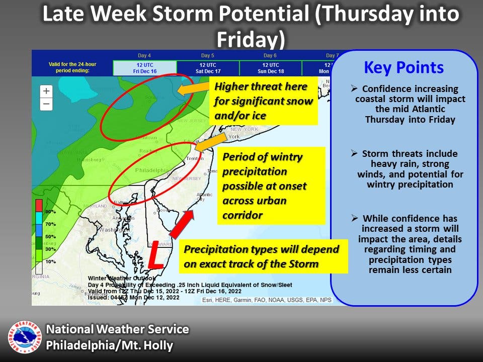
Here's the forecast for the remainder of the week, according to the National Weather Service:
Monday
Mostly cloudy, with a high near 43. North wind around 10 mph, with gusts as high as 20 mph.
Monday night
Mostly clear, with a low around 26. North wind around 5 mph.
Tuesday
Sunny, with a high near 42. Northwest wind around 5 mph.
Tuesday night
Clear, with a low around 26. Northwest wind around 5 mph.
Wednesday
Sunny, with a high near 41. Northwest wind 5 to 10 mph.
Wednesday night
Mostly cloudy, with a low around 28.
Thursday
A chance of snow before 1pm, then rain likely. Mostly cloudy, with a high near 45. Chance of precipitation is 70%.
Thursday night
Rain. Low around 42. Chance of precipitation is 90%.
Friday
Rain likely, mainly before 1pm. Mostly cloudy, with a high near 50. Chance of precipitation is 60%.
Friday night
Partly cloudy, with a low around 34.
Get more local news delivered straight to your inbox. Sign up for free Patch newsletters and alerts.


