Weather
Severe Thunderstorms To Hit Eastern PA: Latest Updates, Timing
Destructive winds, torrential rain, and large hail are heading towards the greater Philadelphia area, forecasters said.

Latest update: A severe thunderstorm watch is in place for the Philadelphia region Friday through 9 p.m. MORE
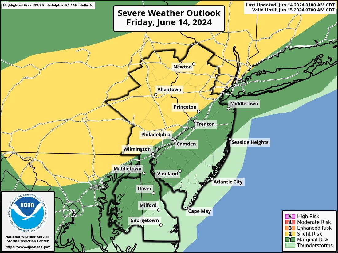
EASTERN PA — The track of the coming storm has shifted slightly, and nearly all of southeastern Pennsylvania is now within the second risk zone for severe weather impacts like damaging winds and large hail, forecasters said.
Thunderstorms and rain will begin during the day Friday but will chiefly impact the area after 5 p.m., according to the National Weather Service.
Find out what's happening in Norristownfor free with the latest updates from Patch.
The storms will continue until around 2 a.m.
The National Weather Service's "slight risk" category, indicated in the yellow below, covers nearly all of eastern Pennsylvania now. As of midday Thursday, only the farther northern and western outlying suburbs of the city were within that zone, with the rest of the region remaining in the green "marginal risk" category.
Find out what's happening in Norristownfor free with the latest updates from Patch.
Travel throughout the eastern seaboard could be impacted, and officials urged the public to be prepared for both potential road closures and flight delays.
The total expected rainfall is less than an inch, but higher amounts are likely in the heart of the thunderstorms, where flooding is possible.
Meanwhile, the coming heat wave now looks to be even more intense once Friday's thunderstorms move out.
"Philadelphia had an early taste of summertime heat with the mercury topping out at 90 degrees back on April 29, but the impending heat wave will be significantly hotter and longer," AccuWeather notes. "The temperature will climb into the mid-90s several days in a row, with the hottest conditions expected around midweek."
Monday will be the first day to reach 90 degrees, but the highs will quickly climb to the mid to high 90s by midweek.
Here's the full forecast:
Friday
A chance of showers and thunderstorms, mainly after 5 p.m. Mostly sunny, with a high near 92. Southwest wind around 10 mph. Chance of precipitation is 30 percent. New rainfall amounts of less than a tenth of an inch, except higher amounts possible in thunderstorms.
Friday night
Showers and thunderstorms before 2 a.m., then a slight chance of showers. Low around 65. North wind around 5 mph becoming northeast in the evening. Chance of precipitation is 80 percent. New rainfall amounts between a quarter and half of an inch possible.
Saturday
Sunny, with a high near 84. North wind around 10 mph.
Saturday night
Mostly clear, with a low around 61. North wind 5 to 10 mph.
Sunday
Sunny, with a high near 85. Northeast wind around 5 mph becoming southeast in the afternoon.
Sunday night
Mostly clear, with a low around 64.
Monday
Sunny, with a high near 91.
Monday night
Mostly clear, with a low around 70.
Tuesday
Sunny, with a high near 95.
Tuesday night
Mostly clear, with a low around 71.
Wednesday
Sunny, with a high near 94.
Wednesday night
Mostly clear, with a low around 71.
Thursday
Sunny, with a high near 95.
Get more local news delivered straight to your inbox. Sign up for free Patch newsletters and alerts.