Weather
Potential Tornado, Powerful Storm Hammers Southeastern PA
Thousands are without power after a storm ripped through southeastern PA early Wednesday evening. Follow along with the latest here.


7:31 p.m.
Evidence of a tornado touchind down looks pretty plain in this photo taken in Warrington during the storm Wednesday.
This was by my home in the Philly area. Looks like a tornado touched down in the Warrington area.#pawx pic.twitter.com/9ibbvj96OC
— Sean Kitchen(@RCPress_Sean) May 29, 2019
6:44 p.m.
Find out what's happening in Norristownfor free with the latest updates from Patch.
In addition to power outages in homes, many traffic signals are also not working. While officials are urging everyone to stay off the roads, exercise extreme caution at intersections if you are out.
6:41 p.m.
Find out what's happening in Norristownfor free with the latest updates from Patch.
A flash flood warning is in effect in Berks, Chester, Delaware, Montgomery, and Philadelphia counties through 10:30 p.m.
6:02 p.m.
Residents in the path of the storm hunkered down in basements and away from windows. At the YMCA in Doylestown, children and staff gathered in an interior hallway to stay safe.
And meanwhile at Doylestown's Club Pilates, the group got creative and gathered in the bathroom.
5:51 p.m.
Thousands are without power in Bucks and Montgomery counties in the wake of the possible touch down of a tornado. A total of 14,575 customers have been impacted in Bucks County, while 6,476 are impacted in Montgomery County. See details here:
5:48 p.m.
The tornado warning expired in Bucks and Montgomery counties at 5:45 p.m., but the storm has left some notable damage.
The storm seemed especially powerful in the Doylestown area, taking down large trees and scattering debris around the area.
Storm tore through Doylestown. This is the aftermath on State Street in downtown Doylestown. Big trees down. Power is out. pic.twitter.com/sx21QJAA0z
— sarahbloomquist (@sarahbloomquist) May 29, 2019
5:07 p.m.
A tornado warning has been issued for parts of Bucks and Montgomery counties Tuesday afternoon. The warning is in effect through 5:45 p.m.
A severe thunderstorm capable of producing a tornado was located over Hatfield at about 5:07 p.m., officials said.
Damage to roofs, windows, and vehicles is likely.
The impacted area includes the central portions of both counties, including: Lansdale, Doylestown, Hatboro, Souderton, Chalfont, Hatfield, Ivyland, Feasterville-Trevose, Fricks, Feasterville, Richboro, Horsham, Telford, North Wales, New Britain, Silverdale, Churchville, Brittany Farms-Highlands, Montgomeryville, and Warminster Heights.
Residents in impacted areas should seek shelter immediately.
Tornado Warning including Lansdale PA, Montgomeryville PA, Doylestown PA until 5:45 PM EDT pic.twitter.com/56UDCmc8rb
— NWS Mount Holly (@NWS_MountHolly) May 29, 2019
1:10 p.m.
A tornado watch has been issued for southeastern Pennsylvania and much of the state Wednesday, marking the second day in a row the National Weather Service has warned of the threat.
The watch covers the entire five-county Philadelphia area, as well as South Jersey and most of Pennsylvania. It is in effect from just after 1 p.m. through 8 p.m.
Here's a glance at the impacted area:
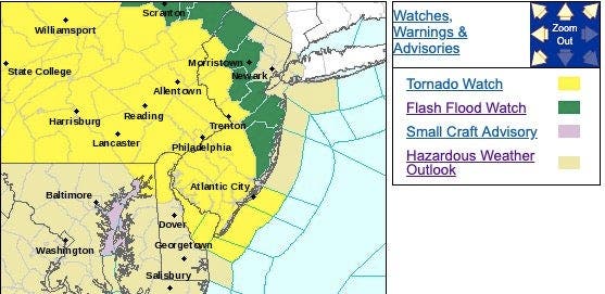
A watch indicates that "conditions are favorable" for the development of tornadoes.
Heavy thunderstorms and torrential rain are possible throughout the area Wednesday, likely beginning at around 4 p.m. and causing a hellish commute in some places.
>>More Severe Weather Coming To PA After Tornado Damage: See Full Wednesday Forecast
In two instances in the past week, on Tuesday night and also once last week, a tornado warning was declared in Chester County later in the evening.
On Tuesday night, a powerful front ripped apart homes and scattered debris near the Berks and Chester County border. The National Weather Service classified it as an "EF2" on the Enhanced Fujita scale, indicating a storm with winds between 111 and 135 miles per hour, causing "considerable" damage.
During a tornado watch, if you see dark, rotating clouds, seek shelter immediately. If the tornado watch is upgraded by the NWS to a tornado warning, you should also seek shelter immediately.
During a tornado, the safest place is in the basement or the lowest floor of a solid structure, away from windows.
Get more local news delivered straight to your inbox. Sign up for free Patch newsletters and alerts.