Community Corner
WEATHER: Cooler Fling of Late Spring
After our first 90-degree days of 2012 last week, Mother Nature flips the switch and turns on natural air conditioning for much of this week.
Personally, I like late spring and early summer quite a bit. It's not my favorite weather of the year compared to October, but this time of the year brings you some of the longest days.
Also, if the pattern is right, you can get some really nice weather that rivals early fall in terms of low humidity and temperatures that won't be as ugly as they will get in a few weeks as we reach the prime of summer heat. Despite chances of showers this week, we will at least see the combination of lower humidity and temperatures that are more typical for early May and not early June.
The cause? Last Friday's storm system that brought rain and wind to the region. The storm system's energy in the upper portions of the atmosphere ended up parking itself over the Great Lakes this past weekend and will slowly migrate through the Northeast over the course of the week.
Find out what's happening in Northamptonfor free with the latest updates from Patch.
That slow migration of energy will result in a cooler than average week, with shower chances nearly each day through the course of the work week. However, it will result in a number of days of free, natural air conditioning.
It won't rain each day in any one location nor will it rain constantly, but the strong sunshine of June will provide the fuel to destabilize the atmosphere and upper level energy to fire up scattered showers and thunderstorms each afternoon.
Find out what's happening in Northamptonfor free with the latest updates from Patch.
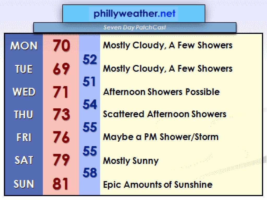
The showers will be fewer in number on Monday and Tuesday but still a possibility each afternoon. The most likely days to get showered upon, at least as of now, appear to be Wednesday and Thursday. Any showers could bring gusty winds but flooding does not appear likely this week with the pattern in place as shower activity will not produce terribly heavy rainfall. Tuesday appears to be the coolest day as the airmass looks to be the most stable and clouds most numerous.
We should slowly break free of the pattern on Friday - a few showers are still possible but nothing widespread. Saturday and Sunday is looking downright awesome as high pressure takes over our weather.
Highs this weekend will reach or exceed 80 both days with plenty of sunshine and modest humidity. Too bad we couldn't bottle this weekend and save it for our next foray into the mid- and upper-90s later on this summer!
-------------------------------------------------------------------------------
Tom Thunstrom is the editor and publisher of Phillyweather.net. You can also follow Phillyweather.net on twitter@phillywx or on Facebook.