Kids & Family
Temperature Plunge Predicted This Week
Storm system that hit Texas is creating this situation for our region
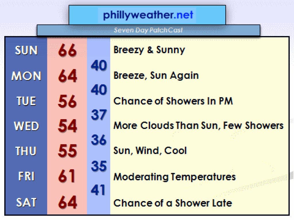
On paper, the pattern next week looks like late winter. That's on paper.
Thankfully, the calendar says April so the "on paper" look means reality will not be that cold. However, this week's temperatures will be several degrees below average. It's nothing unusual, but given that most of the last several months have featured above- to way-above-average temperatures, our current two-week spell of reality will continue.
The culprit next week is the same storm system that brought tornadoes to Texas on Tuesday; it's now in the Atlantic. Thanks to a strong ridge of high pressure in the middle of the ocean, the low is forced to move north and northwest back into eastern Canada. It will create a trough in the mid atmosphere that will reinforce our coolish regime. Adding to that, a couple of weak low pressure centers will work around base of the atmosperhic trough. This results in shower chances for Tuesday and Wednesday. Wednesday will likely shape up as the coolest day of the coming week, perhaps featuring highs that eek into the lower 50s if the day remains cloudy and damp. For those keeping track at home, "normal" highs are in the lower 60s.
Find out what's happening in Perkiomen Valleyfor free with the latest updates from Patch.
Winds will be a story for much of the week as well -- the difference between the low in Eastern Canada and high pressure over Central Ontario will result in a decent north and northwest wind through much of the week. While this past week featured more sunshine than clouds, a couple of days will feature more clouds around -- and cooler temperatures.
The pattern breaks down late in the week, with warmer temperatures returning over the weekend (we hope). It is possible that the following week starts off pretty warm and the potential for upper 70s is not too unrealitistic, but those details are still several days off from finalizing.
Find out what's happening in Perkiomen Valleyfor free with the latest updates from Patch.
Tom Thunstrom is the editor and publisher of Phillyweather.net. You can follow the site on twitter@phillywx or on Facebook.