Weather
Pittsburgh Winter Storm: Timeline For Freezing Rain, Sleet, Snow
A wintry mix is heading for Pittsburgh and southwestern Pennsylvania. Find out here when conditions will be the most treacherous.

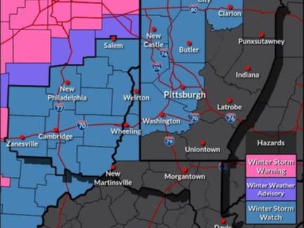
PITTSBURGH, PA — Southwestern Pennsylvania's weather is about to take a turn for the worse, with a messy mix of rain, freezing rain sleet and snow headed for the area. A winter storm watch remains in effect for Pittsburgh and surrounding counties from 1 a.m. Thursday until 10 a.m. on Friday.
According to National Weather Service predictions, there could be heavy mixed precipitation. Total snow and sleet accumulations between 3 and 6 inches and ice accumulations up to two-tenths of an inch are possible.
Travel conditions could become hazardous, the weather service warns.
Find out what's happening in Pittsburghfor free with the latest updates from Patch.
The storm initially will bring rain to the region overnight and for much of Thursday. The latest weather service forecast indicates freezing rain will begin in the Pittsburgh area between 6 p.m. and 8 p.m. before changing to snow. Precipitation is expected to end locally between 6 a.m. and 8 a.m. Friday, although that could change depending on how the storm treks.
Be the first to know what's happening in your community and region. With a free Patch subscription, you'll always be up to date on local and state news: https://patch.com/subscribe.
Find out what's happening in Pittsburghfor free with the latest updates from Patch.
Get more local news delivered straight to your inbox. Sign up for free Patch newsletters and alerts.