Weather
Eastern PA Weather Forecast: Snow Threat Upgraded, Winter Storm Warning Issued
As much as 8 inches could fall Thursday in the Philadelphia region.

Forecasters have again upgraded the threat for snow on Thursday, issuing a Winter Storm Warning across the Philadelphia region. As much as 8 inches could accumulate.
The snow will come after unseasonably warm temperatures Wednesday, when a high near 60 is expected. Temperatures will plunge overnight, with snow starting some time after midnight. Heavy snow will fall at a rate of up to 2 inches per hour between 3 and 10 a.m., according to the National Weather Service.
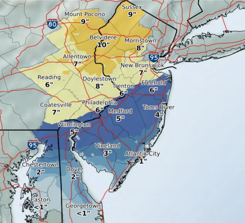
Total accumulation could be as much as 8 inches in Bucks and Montgomery counties. Six to 7 inches is expected in Philadelphia, Delaware and Chester counties. Parts of the Lehigh Valley and Pocono mountain regions can expect as much as 10 inches.
Find out what's happening in Radnorfor free with the latest updates from Patch.
The Winter Storm Warning is in place starting at midnight and going until 4 p.m. Thursday.
Forecasters warn residents to expect a difficult Thursday morning commute.
Find out what's happening in Radnorfor free with the latest updates from Patch.
"Heavy snow, poor visibilities and dropping temperatures will make travel dangerous," the NWS said in its latest storm briefing, issued at 5 a.m. Wednesday.
"The snow should be wet in consistency and therefore will tend to stick to trees and power lines, possibly resulting in some power outages. North to northwest winds will increase late tonight and Thursday with gusts in the 30-35 mph range," the NWS said.
Treacherous travel could continue throughout the day: Temperatures will drop into the teens Thursday night, causing untreated surfaces to freeze up. Some thunder will also be possible during the storm.
Sign up for Patch email alerts and stay up-do-date on the latest storm developments.
Get more local news delivered straight to your inbox. Sign up for free Patch newsletters and alerts.