Community Corner
Winter Weather Advisory For Some; Rain and Thunder For Others
Some in Pennsylvania will get snow, while others can expect heavy rains and even some thunder during a late February storm.

Snowy, icy or rainy weather has moved into the region and will linger through Wednesday.
The type of precipitation that falls depends on how far north you are situated: A Winter Weather Advisory is in effect in parts of the Lehigh Valley, while a Hazardous Weather Outlook is in effect in suburban Philadelphia, including Bucks, Chester, Delaware, Montgomery and Philadelphia counties.
The Winter Weather Advisory in the Lehigh Valley begins at 1 p.m. Tuesday and goes through Wednesday morning. Up to an inch of snow, sleet and freezing rain is expected there.
Find out what's happening in Radnorfor free with the latest updates from Patch.
“Untreated roads will become slippery due to some snowfall and then some icing,” the National Weather Service said in the Winter Weather Advisory.
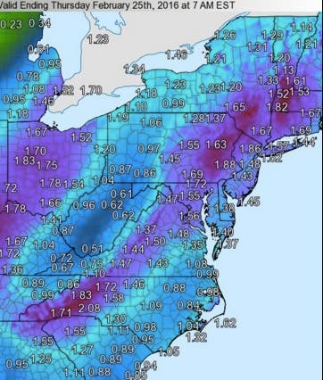
For the areas under a Hazardous Weather Outlook, three days of rain is expected, with the most falling on Wednesday.
Find out what's happening in Radnorfor free with the latest updates from Patch.
Heavy rain is expected Wednesday, leading to the possibility of localized flooding in areas with poor drainage, according to the NWS. Thunderstorms could accompany the rain Wednesday, bringing wind gusts of up to 50 miles per hour.
The wet weather should clear by Friday, when sunshine and a high in the upper 30s is expected.
Here is the forecast for the Philadelphia region:
Today: Periods of rain. High near 37. Northeast wind 10 to 17 mph. Chance of precipitation is 100%. New precipitation amounts between a tenth and quarter of an inch possible.
Tonight: Periods of rain. Low around 36. Northeast wind 8 to 14 mph. Chance of precipitation is 90%. New precipitation amounts between a tenth and quarter of an inch possible.
Wednesday: Rain likely before noon, then showers after noon. Areas of fog before noon. High near 47. Northeast wind 6 to 8 mph becoming southeast in the afternoon. Chance of precipitation is 90%. New precipitation amounts between a quarter and half of an inch possible.
Wednesday Night: Showers and possibly a thunderstorm before midnight, then showers likely. Some of the storms could produce gusty winds and heavy rain. Low around 46. Southeast wind 8 to 11 mph becoming southwest after midnight. Winds could gust as high as 22 mph. Chance of precipitation is 100%. New precipitation amounts between a half and three quarters of an inch possible.
Thursday: A chance of showers. Cloudy, with a high near 53. West wind 8 to 16 mph. Chance of precipitation is 30%. New precipitation amounts of less than a tenth of an inch possible.
Thursday Night: A chance of showers before midnight. Mostly cloudy, with a low around 31. Chance of precipitation is 30%. New precipitation amounts of less than a tenth of an inch possible.
Friday: Mostly sunny, with a high near 39.
Get more local news delivered straight to your inbox. Sign up for free Patch newsletters and alerts.