Neighbor News
Cooler temperatures and risk for showers highlight Sunday; warmer and muggy weather arrives by the middle of the week
A cold front moves offshore by tonight, with improving conditions for Monday. We return to summer conditions once again by early Wednesday.
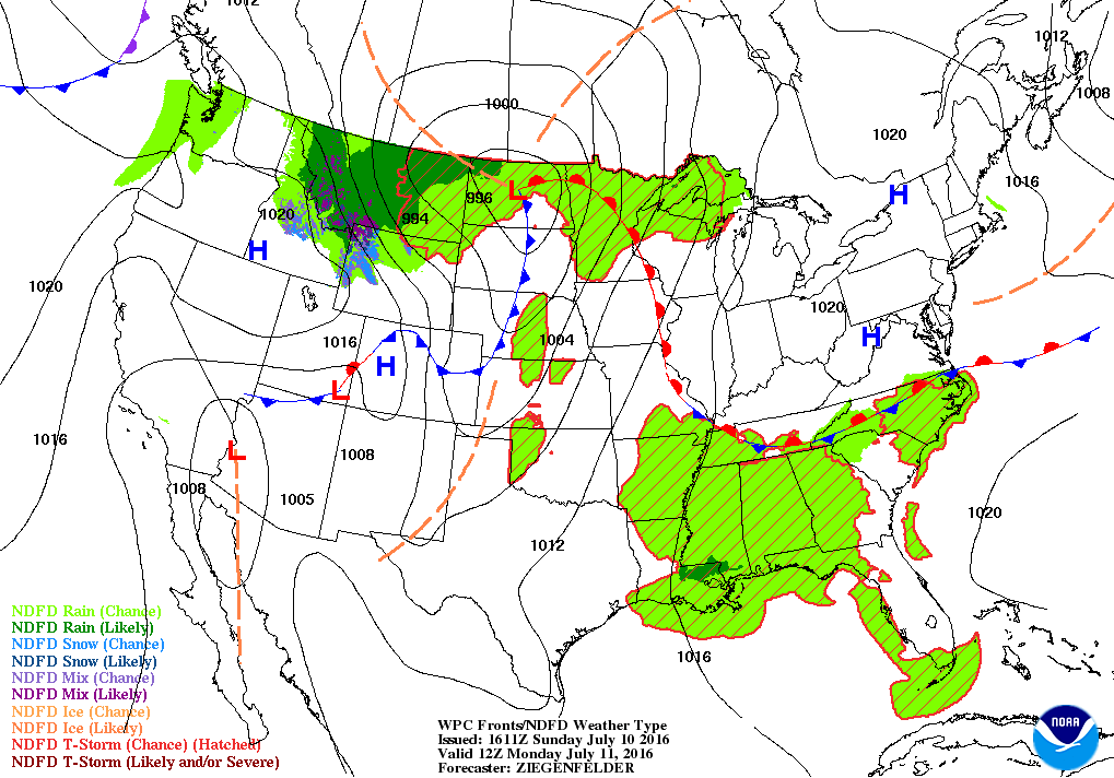

Weather Forecast Discussion for Rhode Island on July 10, 2016
It has quite a difference in temperatures around the Ocean State this weekend, compared to the weekdays. High temperatures for Providence only made its way to 73 on Friday and 70 on Saturday. Northeast winds taking cooler air off the waters was the major culprit for the below normal temperatures, along with overcast skies.
For the rest of Sunday, a low pressure center over New Hampshire will keep us under cloud cover, with the risk for passing showers and thunderstorms this early afternoon. High temperatures will only reach the lower 70’s. The low will move out to sea by tonight, but we will keep the risk for an isolated shower or thunderstorm into 1 a.m. Also, expect patchy fog by 1 a.m., as the dewpoint and air temperature come close together. We will see the atmosphere become more stable, as weak high pressure ridging builds in from the west. Expect low temperatures Sunday night in the lower 60’s. We will keep some moisture in the atmosphere on Monday, giving us only partial sunshine. High temperatures will reach the middle 70’s. A high pressure center moves just south of Rhode Island Monday night, giving us partly cloudy skies. Low temperatures are predicted to fall into the lower 60’s.
Find out what's happening in East Providencefor free with the latest updates from Patch.
As we head into Tuesday, the high will slowly move away from Cape Cod, but continue to influence our weather. Also, an upper level ridge will slowly work its way towards the eastern U.S. With winds shifting to the south and southwest, along with this ridge, temperatures will be increasing. We will continue to see mostly sunny skies, but high temperatures will climb into the middle 80’s. With the southwest winds will also mean more moisture coming up from the south. So, our dewpoint temperatures will begin to reach the middle to upper 60’s, meaning oppressive conditions. Low temperatures Tuesday night will only fall into the upper 60’s. By Wednesday, dewpoints may be as high as the lower 70’s. With sunny skies and highs in the lower 90’s inland, the heat index may make it feel near 100 degrees. Partly cloudy skies are expected Wednesday night, with lows in the lower 70’s. However, it will be very uncomfortable for sleeping conditions without a fan or air conditioner.
By Thursday, the upper level ridge axis will move off to our east. Also, a strong low pressure system between 50 and 60 degrees north will bring more moisture closer to the east coast. We will start off with bright sunshine to start the morning, with increasing clouds throughout the afternoon. So, I will call for partly sunny skies with highs in the upper 80’s. With a cold front in the Ohio River Valley, there is the slight risk for a shower or thunderstorm by the early evening, between 5 and 7 p.m. As the cold front moves into the Mid-Atlantic Thursday night, the risk for showers and thunderstorms increases slightly. Low temperatures Thursday night will only fall into the lower 70’s. The best chance for any precipitation is during Friday, as the cold front pushes through Southern New England. Expect highs in the middle 80’s if we keep overcast skies. However, if we see breaks of sunshine, high temperatures may reach the upper 80’s.
Find out what's happening in East Providencefor free with the latest updates from Patch.
Any showers and thunderstorms end by midnight, as a high pressure center moves over Southern New England by early Saturday morning. Low temperatures Friday night will reach near 70 degrees. We will see sunny skies on Saturday, with highs in the middle to upper 80’s. Low temperatures Saturday night will fall into the middle to upper 60’s. Looking ahead to next Sunday, a weak high pressure ridge will remain over Southern New England. We will see partly sunny skies by the afternoon, as the American model is showing showers and thunderstorms in the Mid-Atlantic moving straight north. A weak disturbance may bring the risk for showers and thunderstorms by the early evening. High temperatures are forecast to reach the middle 80’s next Sunday.
Jim Laurie is a local meteorologist who earned a B.S. in Meteorology at Lyndon State College in Lyndonville, VT. Jim has fifteen years of professional experience, with eight years in the field of marine meteorology.